
21.48± Acres Of Recreation Land Near Laurel, Indiana
0 Laurel Road, Lot#WP001, Laurel, IN | Lat/Lng: 39.5020, -85.1684
$160,000
21.48 ac.
06/05/2026
ACTIVE

Description
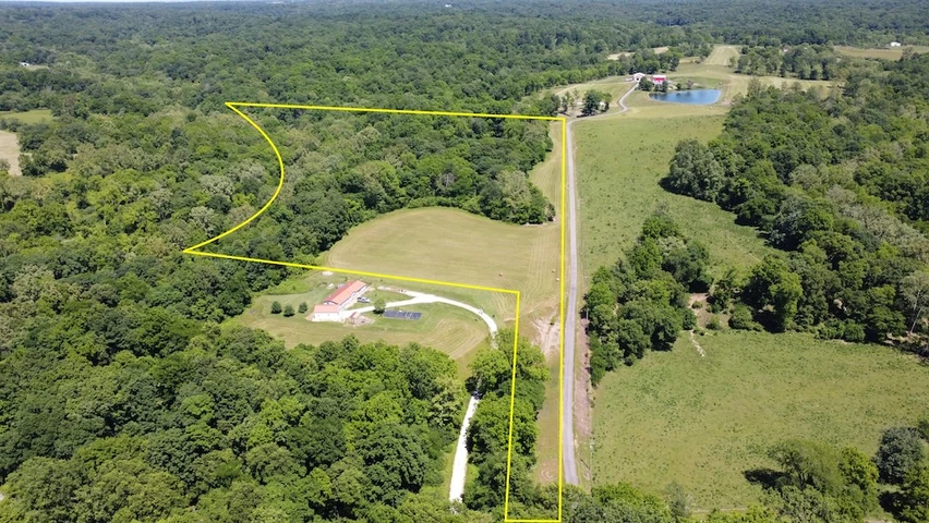
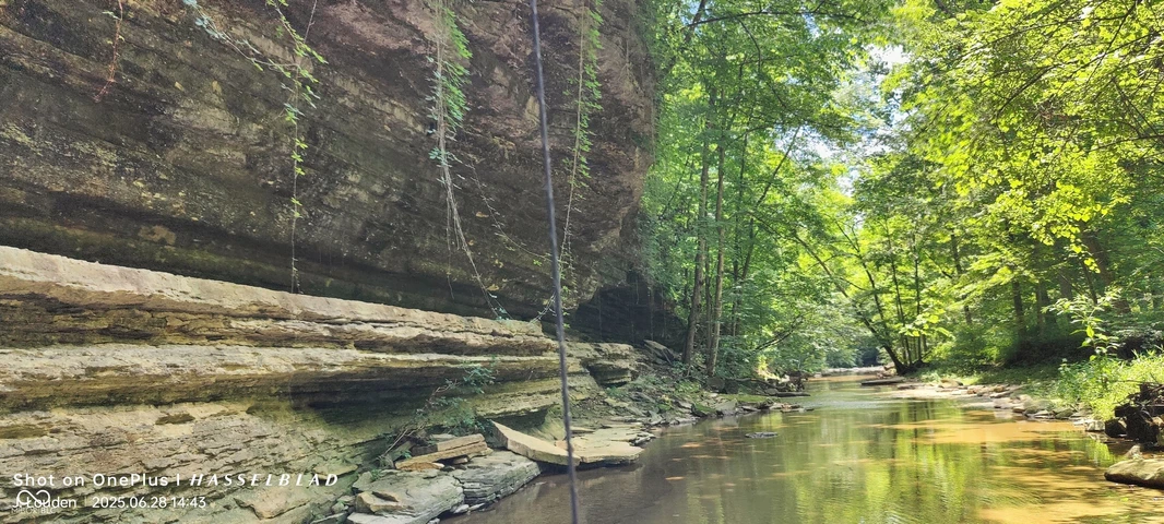
Located in Franklin County, near Laurel, Indiana, this 21.48 acre recreational property features wooded habitat, open ground, multiple access points, and existing improvements. The nearest address is 21114 Laurel Road, Laurel, IN 47024, and is provided for location reference only. The property consists of a mix of open hay ground and timber, creating opportunities for hunting, recreation, camping, habitat management, and future improvements. The open field area provides space for food plots, native grass plantings, camping activities, or a potential future building site, subject to local regulations and approvals. The balance of open and wooded acreage creates a landscape that supports a variety of outdoor uses. One of the most appealing aspects of this tract is its topography. The rolling terrain, wooded draws, and natural cover create excellent habitat diversity while also making much of the property accessible and usable. The landscape provides areas where wildlife can travel, feed, and seek cover year-round. Combined with the nearby water source and the surrounding agricultural land, the property offers features commonly sought by recreational landowners. Access is available from the western boundary through the primary road frontage. The existing driveway is NOT part of this property. An additional advantage is the property's frontage along Laurel Road, which borders the entire northern boundary. Sayers Branch Creek flows along much of this northern edge and may limit vehicle access in certain locations. However, access by ATV, UTV, or on foot is achievable, providing additional options for reaching various portions of the property. Several established trails are present throughout the wooded acreage. While they have not been maintained in recent years and would benefit from clearing, they provide a solid starting point for restoring a trail system suitable for hiking, hunting access, wildlife observation, and recreational riding. A small cabin/shed is located on the property and is in usable condition. It provides a practical place to store equipment, take shelter from the weather, or establish a base camp while enjoying the property. The structure is accessible by vehicle and provides immediate recreational functionality. Utility services may be available nearby due to nearby residences. Buyers should conduct their own due diligence regarding utility availability, connection costs, and any intended future improvements. With a combination of open hay ground, mature woods, creek frontage, multiple access points, existing trails, and a usable shed/cabin, this 21.48 acre Franklin County property offers a well-rounded recreational tract in a quiet rural setting near Laurel, Indiana. This property is located approximately 1 mile from Laurel, 13 miles from Connersville, 15 miles from Brookville, 20 miles from Batesville, and approximately 44 miles from Cincinnati, Ohio.
Details
County: Franklin
Zipcode: 47024
Property Type One: Recreational Property
Property Type Two: Undeveloped Land
Brokerage: Whitetail Properties Real Estate
Brokerage Link: www.whitetailproperties.com/agents/tyler-fritz
Apn: 240210400001001010

Tyler Fritz
Whitetail Properties Real Estate
(219) 242-2701
By clicking the button, you agree to our Terms of Use and Privacy Policy.


Nearby Listings
Decatur County, IN
$1,750,500 - 201 ac.
Henry County, IN

$980,000 - 23 ac.
Jennings County, IN

$219,900 - 36 ac.
Jennings County, IN

$229,900 - 38 ac.
Decatur County, IN

$452,000 - 30 ac.
Fayette County, IN
$550,000 - 12 ac.
Franklin County, IN

$2,600,000 - 63 ac.
Jennings County, IN

$720,000 - 80 ac.
Preble County, OH

$1,299,000 - 55 ac.
Preble County, OH
$659,000 - 57 ac.