
Hillside Ranch
1890 Mamie Rd., Greenville, TX | Lat/Lng: 33.1031, -96.0580
$1,800,000
83 ac.
01/21/2026
ACTIVE

Description
Situated in the heart of Hunt County, this 83 +/- acre ranch offers a rare blend of recreational enjoyment, productive agricultural land, and long-term upside, all just minutes from Greenville, Texas. Thoughtfully cared for and rich in natural character, the property has served as a cherished family retreat while continuing to generate agricultural income. With live water, scenic elevation changes, historic improvements, and immediate proximity to 600 acres of protected river bottomland, Hillside Ranch presents an exceptional opportunity for a buyer seeking both lifestyle and legacy.
Location
Centrally located within Hunt County, the property lies approximately four miles southeast of downtown Greenville, Texas. Its position offers convenient access to local amenities while maintaining a private, rural atmosphere. Proximity to Greenville and the broader DFW metroplex enhances the ranch's appeal for both full-time ownership and weekend enjoyment, making it an ideal retreat without sacrificing accessibility.
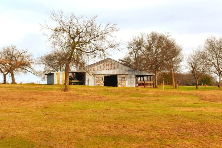
Improvements
The ranch is anchored by a large (51'x33') century-old barn that stands as both a functional asset and a physical reminder of the property's past. In good condition, it offers generous space for equipment storage, tools, and flexible use, including gatherings or entertaining. Nearby, a secondary supporting structure (45'x18') provides additional versatility and is well suited for horse boarding or expanded equipment storage. Together, these improvements support agricultural operations while preserving the authentic character of a working East Texas ranch.
Live Water & Water Resources
One of the ranch's most compelling natural features is its northern boundary along the Sabine River bottom, which adjoins approximately 600 acres of heavily treed, city-owned and protected land held by the City of Greenville. This preserved corridor provides a scenic, wildlife-rich backdrop that will remain intact for generations.
Flowing creeks traverse the property, offering both functional and recreational value. Approximately two-thirds of the property lies within the floodplain, creating unique opportunities for water enhancement. The ranch currently includes two ponds and a 1.5-acre lake that is being cleaned out and prepared for customization, allowing a new owner to shape the water feature to their vision.
Land, Topography & Habitat
The ranch features a diverse mix of elevation and terrain, combining scenic views with productive bottomland. The southern portion of the property (well suited for future homesites) sits at approximately 530 feet in elevation and overlooks northern fields resting closer to 480 feet. A natural bluff rises roughly 50 feet above the surrounding landscape, offering elevated vantage points and expansive views across the fertile lowlands below.
The ranch is well maintained and easily navigable via an internal road system in good condition, accessible by most vehicles and especially four-wheel drive.
Wildlife is abundant, with deer, bobcats, coyotes, feral hogs, dove, and waterfowl. A diverse mix of grasses, native vegetation, and mature trees further enhances habitat quality and overall land character.
Agriculture & Income
In addition to its recreational appeal, the ranch is actively used for agricultural production. Well-maintained Bermuda fields are currently producing approximately 200-250 bales per cutting, with two to three cuttings annually. While no cattle are presently on the property, the land is well suited and fenced for both farming and ranching operations, offering flexibility for continued income generation or future expansion.
History & Heritage
The ranch's history is deeply rooted in Hunt County's agricultural and railroad past, with tangible details that remain visible today. Etched into the concrete floor of the main barn is the year "1917", marking the time when this enduring structure was built. Many of the barn's massive vertical beams were constructed using reclaimed railroad ties from the rail line that once ran along what is now Mamie Road, directly tying the property to the region's early transportation and farming infrastructure.
Long before the barn was constructed, the land itself was highly productive. In the late 1800s, these rich soils were planted in cotton, with short levees built by mule-drawn scrapers to protect the fields from seasonal flooding. Portions of those original levees remain intact today, serving as lasting reminders of the land's early stewardship.
Cotton harvested from the property was hand-picked and hauled by horse-drawn wagons to the nearby Katy Railroad, where trains would stop to load bales bound for the Greenville cotton gin. During harvest season, trains regularly traveled between Greenville and Mineola, watching for wagons arriving from surrounding farms-making this area an active contributor to Hunt County's agricultural economy.
This layered history, embedded in the barn, the levees, and the land itself, adds a level of authenticity and continuity that cannot be replicated.
Details
County: Hunt
Zipcode: 75402
Property Type One: Farms
Property Type Two: Ranches
Property Type Three: Hunting Land
Brokerage: Tyler Thomas
Brokerage Link: ttranchgroup.com

TT Group
Tyler Thomas
(214) 396-9692
By clicking the button, you agree to our Terms of Use and Privacy Policy.


Nearby Listings
Lamar County, TX

$159,900 - 10 ac.
Kaufman County, TX

$3,995,000 - 55 ac.
Hopkins County, TX

$1,487,500 - 175 ac.
Rains County, TX

$2,495,000 - 79 ac.
Kaufman County, TX

$2,332,000 - 113 ac.
Fannin County, TX

$280,000 - 13 ac.
Wood County, TX

$3,400,000 - 34 ac.
Dallas County, TX

$4,321 - 456 ac.
Hunt County, TX

$549,000 - 3 ac.
Hopkins County, TX
$1,108,000 - 76 ac.