
Soft Hills. Open Woods. No Permission Needed
633 Weaver Ford Road, Grassy Creek, NC | Lat/Lng: 36.5588, -81.3897
$37,995
1.9 ac.
07/17/2025
ACTIVE

Description
Owner Financing:
- $729 down (plus the $499 doc fee)
- $729 down $728.56/Mo for 72 months (plus prorated taxes and note maintenance fee)
You dont need to ask anymore.
Not for permission. Not for a site number. Not for peace.
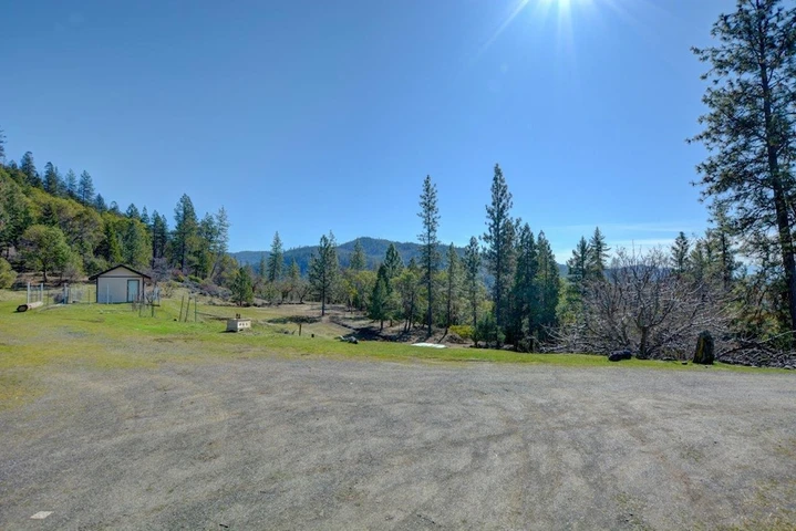
This 1.90-acre lot in Ashe County, North Carolina, gives you something public campgrounds never will: a quiet space thats all yours. No packed sites. No check-out time. No shared fire rings or wondering whos camped here before.
Located just 2 miles from Grassy Creek, this land sits at 2,545 feet elevation with easy paved road access from the highway right to your property. You dont need 4WD or a compassjust pull in and youre there.
Its a peaceful, rural setting with rolling hills, open fields, and tall mature trees spaced just wide enough to let the sun pour in. The lot starts out gently sloped near the front, then levels out into a large flat area that gives you options for setting up camp, parking your trailer, or pitching your tent. You can clear a few trees if you like, but honestlyits ready for you now.
This isnt a patch of overgrown brush or a rocky slope. Its real land with open woods, scattered tree lines, and wide views, sitting in a quiet mountain development where the roads were recently paved and utilities were buried underground. That means no ugly poles, no messjust smooth access and peace of mind.
Power and cable are already to the property line. You can plug in if you want or go completely off-grid. Theres no pressure either way. Youre free to use the land how you want, when you want.
Youll need to add a septic system and well later if you decide to go permanent, but that can wait. For now, its the perfect escape from the weekday grind.
And when youre ready to get out and explore, youre just a short drive from some of the best outdoor spots in the region.
Mount Jefferson State Natural Area
New River State Park
Lansing Creeper Trail Park
Grayson Highlands State Park (just across the state line in VA)
Each one offers a new trail, a quiet riverbend, or a mountain overlook worth sitting at for a while. You wont need to travel far to find adventureor solitude.
The development itself feels private but connected. You're not miles from civilization, but you also wont hear it. You're close to town and surrounded by land that still feels wild. With low county taxes ($60/year) and buried utilities already in place, this lot gives you the foundation for a stress-free retreat without the price tag or pressure to build.
And here's the best partyou dont have to pay all at once.
You can make it yours today with just a $729 down payment, then take your time with monthly payments of $728.56. Its a simple plan, no banks involved. Just a $499 one-time doc fee, then youre off and running.
No credit check. No complicated forms. No long approval wait.
Just say the word, and this peaceful stretch of Ashe County becomes your spot.
Prefer to buy it outright? Its yours for a cash price of $37,995.
Whether youre looking to escape for long weekends or stay all season, this land gives you something real. Something that belongs to younot to a campground, not to a reservation system, not to a park schedule.
Youve spent enough time sharing space. Now its time to own it.
Roll up with your gear. Kick back under the trees. Watch the sun drop behind the hills without a neighbor asking what time youre packing up.
That feeling? Thats freedom.
Let us know if you want to see it in person or get more info. Were here to helpno pressure, no sales pitch. Just real land, for real people, who are ready to have their own place to return to.
State: NC
County: Ashe
Zip: 28631
Size: 1.90 acres
Apn: 05322092010
Legal Description: "LOT NO. 10 as shown on a plat entitled ""Chincoteague"" of record in the Ashe County Public Registry in Plat Book 6, at page 421, to which recorded plat reference is hereby made for a metes and bounds description of said lot.
This conveyance is made subject to that certain Declaration of Protective Covenants, Conditions and Restrictions affecting said subdivision which appears of record in the Ashe County Public Registry in Book 355, at page 662, to which reference is hereby made for a specific recital of said covenants and restrictions.
"
Lat/Long Coordinates:
Nw: 36.558934, -81.390571
Ne: 36.559193, -81.389552
Sw: 36.558409, -81.389573
Se: 36.558839, -81.388860
Elevation: 2545 feet
Annual Taxes: Approx. $60 per year
Zoning: Residential Property, Recreational Property, Hunting Land
Flood Zone: No
HOA/POA: No
Improvements: No improvements done.
Access: Paved Road
Water: Will need to install a Well
Sewer: Will need to install a Septic System
Utilities: Electric
Owner Financing:
- $729 down (plus the non refundable doc fee of $499)
- $729 down $728.56/Mo for 72 months (plus prorated taxes and note maintenance fee)
We do not offer owner financing for residential use or full-time living on the property during the financing term.
Details
County: Ashe
Zipcode: 28631
Property Type One: Recreational Property
Property Type Two: Residential Property
Property Type Three: Hunting Land
Brokerage: Grounded Properties Land
Brokerage Link: www.groundedpropertiesland.com/
Apn: 05322092010

Chris Palsgrove
Grounded Properties Land
(919) 336-0864
By clicking the button, you agree to our Terms of Use and Privacy Policy.


Nearby Listings
Grayson County, VA

$8,500,000 - 350 ac.
Watauga County, NC

$199,900 - 12 ac.
Watauga County, NC

$49,900 - 2 ac.
Wilkes County, NC

$29,900 - 10 ac.
Wilkes County, NC

$66,000 - 22 ac.
Wilkes County, NC

$79,900 - 10 ac.
Wythe County, VA
$389,000 - 8 ac.
Wilkes County, NC

$49,900 - 10 ac.
Wilkes County, NC

$39,900 - 2 ac.
Wilkes County, NC

$89,900 - 10 ac.