National Land For Sale (81396 results)
Want to post your listings on AcreValue? View Listing Plans
AcreValue offers multiple types of land for sale in every state in America, so if you’re looking for a new ranch, farm, recreational property, hunting ground, developmental property, or land investment you’ve come to the right place. Regardless of what your needs or objectives are for your land, we have a large inventory of available parcels that are updated regularly. Therefore, it’s very likely that we have the perfect parcel that meets all the search criteria & specifications that you’ve been searching for. Additionally, because our land for sale listings are always being updated due to the frequency of land being sold or new land listings being put on the market, make sure that you are checking back with AcreValue regularly for updates. When you find the perfect land parcel and you are ready to take the next steps you can easily connect directly with the listing agent to help you facilitate your land purchase. We wish you the best of luck in finding your next ranch, farm, recreational property, hunting ground, developmental property, or land investment.


05/19/2025
$26,500,000
13453 ac.
ACTIVE
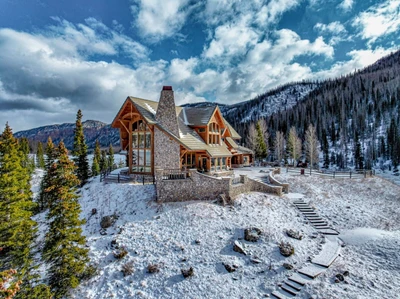
Yellowstone County - 7200 Pineview Rd, Custer, MT
The Windancer
The Windancer is located in one of the most sought-after locations in Montana, The Bull Mountains. A beautiful 2,288 square foot log home on the property overlooks Buffalo Creek, providing unmatched early morning views of the resident Elk, Mule Deer, and Antelope herds that call this property home. Productive hay fields are strategically placed with wildlife management in mind, surrounding a 10-acre spring fed reservoir stocked yearly with Yellowstone Cutthroat Trout. Populations of elk exceeding 300 head are common on the ranch, and unlike other areas of The Bulls the elk are not seasonal, they call this ranch home year-round. Numerous elk have been harvested here over the years, some scoring well over 360, and in recent years a set of 410" sheds were found within the ranch boundaries.
The Windancer Ranch is in the 590 special permit area. With having Landowner Preference this permit has very high odds of drawing year after year. Last year odds were 100% draw for both resident and non-resident for archery. The rifle permit was 70% for residents and 100% for non-residents.
Acreage Breakdown
10,253 Deeded Acres
2560 BLM Lease Acres
640 State Lease Acres
Improvements
The Windancer is well equipped with 3 different housing options. The home favored by the owners is a beautiful Log Home built in 1977 and later remodeled in 1998. The owners selected a perfect location to build this 2,288 square foot log home. A lightly timbered driveway leads to the entrance of the home, where exceptional craftmanship is evident immediately. While entering the house through the wrap-around deck you are greeted with impressive vaulted ceilings in the main living area as well as a cozy fireplace to hunker up around after cold morning hunts on the ranch. Continuing past the living area youll find the kitchen, accentuated with high-end amenities including tiled floors, granite countertops, and stainless-steel appliances. An oversized two car garage is attached to the house by way of a large mud room that includes a half bath, perfect for cleaning up when coming in from outside. An additional pole barn for dry storage of equipment, vehicles and ATVs is easily accessible near the log home entrance as well.
The Windancer also has two smaller homes on the property. The managers house is located on the north side of the property, overlooking Buffalo Creek. Here a person can watch the herd calve, keep an eye on the big bulls as they enter the bedding ground, or just watch the sun go down over the horizon. The managers house is where the work happens. An elaborate set of pipe working corrals have been built to bring the herd into brand, precondition and ship. There are several outbuildings around the managers house including a barn, shop, and three-sided sheds for the animals.
Last but not least is the Hunting Cabin, also known as Elk Camp. Elk Camp is located in Section 10 on the ranch, on the south side of Buffalo Creek. Elk Camp is a 1,252 square foot hunting cabin where the hunting camaraderie comes together. This 3-bedroom 2 bath home and has all the amenities needed to carry out a successful hunt. Many of the ranchs hunts begin here, as the hunters can walk from here to stands near by and setup up over water holes, or make a move on bugling bulls coming out of the barley fields. A fire pit here is the perfect place to enjoy conversations after a long day in the field while BBQing on the deck or listening to elk rut in the hay fields.
General Operation
The current owner has run as many as 500 mother cows on The Windancer, and on wetter years is confident the ranch could run more. As a result, income potential on the ranch is significant, especially considering current cattle prices at an all time high. Historically the owner would calve out on Buffalo Creek, and then move the cows to the south in Antelope Creek for the summer, bringing them home in late October or early November to wean and sell.
Between hay fields on the ranch and the hay barley/oats planted in the tilled acres, a good year with plenty of rain can guarantee all the feed a cattle herd would need. Up to 800 ton of hay has been produced on the ranch when properly fertilized and sprayed. The Windancer is a self-sustaining operation with a profitable bottom line.
Water Resources
The Windancer is one of the best watered ranches in this area. This feature makes this ranch one of the most versatile ranches in the Bull Mountains. A spring fed reservoir is rarely dry even in the most drought-stricken years, and with multiple wells and water lines, water on the ranch is guaranteed. This asset holds true in late August and early September when the animals need it most. Water Rights will transfer to a buyer upon request.
Climate
Montanas climate offers diverse seasons, with average summer temperatures in the mid-80s and average winter snowfall of approximately 40 inches. The area receives around 13 inches of rainfall annually, making it well-suited for both ranching and recreational activities.
Mineral Rights
All minerals currently owned by the seller will transfer.


03/17/2025
$18,495,000
480 ac.
ACTIVE
Mineral County - 2418 USFS Rd 526, Creede, CO
Imagine owning a secluded sanctuary where every corner of the landscape invites you to connect with the raw beauty of the San Juan Mountains. Red Mountain Ranch is just that, a 480 deeded acre one of a kind property, offering an opportunity to raw natural resources, recreational possibilities, and unmatched privacy and access.
The property features two 7-acre lakes, over 3 miles of improved trout streams, and Red Mountain Creek, which flows through the entire length of the property. Red Mountain Creek, along with the lakes and streams, creates a private fishery that is completely under your management, offering exclusive fishing opportunities in its pristine waters. Abundant with brown trout, cutthroat trout, and rainbow trout, this fishery ensures a consistent and rewarding fishing experience while allowing owners to maintain the health and sustainability of its aquatic ecosystem. With no public access or pressure from outside anglers, the property provides a rare opportunity to preserve and enjoy a thriving, unspoiled fishery.
Elevations ranging from 9,300 to 9,700 feet offer spectacular views of Rhoda's Arch, the surrounding landscapes, and nearby 12,000+ foot peaks, including Piedra Peak, located just four miles away. The land itself is a diverse mix of aspens, spruce, and willows, further contributing to the property's raw beauty and ecological richness.
The estate includes multiple well-appointed structures, including an Engelmann Spruce Log Cabin boasting 4,193 square feet of living space with extraordinary high ceilings, a floor-to-ceiling three-story fireplace, and expansive windows showcasing the properties breathtaking views. Additional structures on the ranch include a large barn with a caretaker's apartment above, a second log cabin, a fully equipped workshop, and a dedicated yoga/exercise room near the main house.
Red Mountain Ranch is located in Game Management Unit 76, a highly sought-after area for big game hunting that is home to trophy-class wildlife, including 330 to 380 class bull elk and moose. The property is enrolled in the Landowner Preference Program and historically receives one bull elk tag, three cow elk tags, and one application for mule deer. This unit is truly considered one of the best Game Management Units in the region for hunting moose and elk, making it a prime location for hunters.
Recreational opportunities abound at Red Mountain Ranch, including hunting, fishing, swimming, hiking, rock climbing, and ATV exploration. The land's remote nature, year-round accessibility, and raw, unspoiled beauty make it feel like stepping back into the 1800s. It is a place where the land has remained largely untouched and protected from the outside world, providing a private sanctuary for those who call it home.


03/10/2025
$23,500,000
3173 ac.
ACTIVE
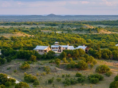
Callahan County - 7985 FM 2228, Baird, TX
PROPERTY DESCRIPTION: Nestled among the high hilltops of the Callahan Divide, Spring Mesa Ranch is a true legacy property, offering breathtaking landscapes, first-class accommodations, and a rich frontier history. Named after the mountain peak that rises 2,182 feet within its borders, this ranch has been meticulously restored to reflect the look and feel of a Texas cattle ranch from the 1840s. A large-scale cedar removal and native grass restoration program has brought the owner's vision to life, creating some of the most scenic and productive wildlife habitats and rangelands in the region.
The land features 38 earthen stock tanks, the headwaters of Brushy and Cottonwood Creeks, seven miles of all-weather caliche roads, excellent fencing and cross-fencing, cattle pens, and nine pastures. Atop the hills, a skeet shooting pavilion and a sanctuary with a prominent cross offer breathtaking views. Upon entering through the main gate, a private all-weather rock road winds through the foothills, revealing the magnificent hilltop residencean 8-bedroom, 8-bathroom home with 10,401 square feet of indoor living space, a swimming pool and outdoor entertainment area, all built with no expense spared.
East of the headquarters, the hill country style Happy House' sits in a majestic oak-covered setting, providing a serene retreat. Located on FM 2228, a ranch employee's manufactured home sits in a nice grove of oak trees. Both homes are in very good condition. Additional improvements include a 100' x 45' eight-stall horse barn with an office and a 60' x 60' shop with an apartment.
Once part of the historic 50,000-acre Cross Bar Ranch, Spring Mesa Ranch stands as a testament to vision, conservation, and Texas heritage. With its unparalleled natural beauty, modern amenities, and historical significance, this extraordinary property offers a rare opportunity for ranching, recreation, and the creation of a lasting family legacy.
LOCATION: Spring Mesa Ranch is located on the western edge of the Cross Timbers & Prairies Region of Texas, south of Interstate 20, between Putnam and Baird in east-central Callahan County, near the historic community of Admiral. It is approximately 2 hours and 30 minutes from Dallas and 2 hours from Fort Worth. Nearby towns include Cross Plains (12 miles south), Baird (16 miles northwest), Cisco (25 miles northeast), Abilene (37 miles northwest), and Midland (186 miles west).
Physical Address: 7985 FM-2228, Baird, Texas 79504
DIRECTIONS: From Dallas and Fort Worth, take I-20 west for approximately 120 miles to Putnam, Texas. Just past Putnam, take Exit 313 to FM-2228 and turn left onto FM-2228. Travel south for approximately 11 miles to the ranch entrance on the right.
ACCESS & ROADS: Ranch has 2 miles of FM 2228 frontage and access by a roadway easement off CR461 (no roadway easements run through Spring Mesa). The property features 7 miles of interior all-weather caliche roads in excellent condition. The main home one-half mile from the entrance and is surrounded by a hog-proof fence. Both perimeter and interior fencing are in excellent condition, with interior cattle guards allowing easy travel throughout the ranch. Two gravel pits provide a convenient source of road base for maintenance.
HISTORY: The current ownership acquired 441+/- acres in 2004, followed by additional land acquisitions, forming Spring Mesa #1 (the northern half of the ranch). Years later, an additional 1,587+/- acres were added, creating the southern half of the now 3,173+/- acre Spring Mesa Ranch. The land was originally heavily wooded with cedar, and native grasses were in poor condition. Under the vision of Texas oil and gas pioneer Dick Lowe and Dr. John Merrill, former head of TCU's Ranch Management program, the ranch underwent a careful transformation to restore and revitalize the ecosystem. Restoration efforts began with the end goal of taking this ranch back to the 1800s. Through meticulous land management, invasive cedar trees were removed, revealing hidden springs, native grasses and hardwoods.
Once part of the vast 50,000-acre Cross Bar Ranch, Spring Mesa Ranch is steeped in history, with reminders of the past still scattered across the ranch. Notable historical features include:
Harper House Remnants: Built by a family who purchased land in the 1890s. The original fireplace, chimney, and cistern remain.
Old String Town Site: The original Cross Bar Ranch owner, Mr. Cordwendt, built 14 houses for his hired help. Though little remains, the old swimming hole/pond still exists.
Cordwendt's Hand-Dug Water Well: A well dug by Mr. Cordwendt during his ownership.
Hester Twins Gravesite (1895): The burial site of two young girls who succumbed to typhus while traveling by wagon.
MAIN HOUSE: The primary residence is a Texas Hill Country-style masterpiece, originally built in 2005 as a family retreat. It underwent significant additions in 2008 and 2010, expanding into a 16,770+/- square-foot compound with 10,401 square feet of HVAC-controlled interior space and 6,369 square feet of outdoor patio and entertainment area. Designed by David Lewis Builders, the home is ideal for entertaining and relaxation.
The 8 bedroom/ 8 bathroom residence consists of three interconnected buildings under the same roof being further described as:
East Building (2005): Features three bedrooms, three bathrooms, a full-size kitchen, a walk-in gun safe, a pool table, and an open living room with wood-burning fireplace. The upstairs includes a children's bunkroom, full bathroom, and loft-style living room.
Middle Building (2008): Houses two guest bedrooms with full bathrooms, two half baths, a large kitchen with an island, an impressive fireplace centerpiece open on four sides, and two open living/ entertainment areas. A crow's nest at the top provides 360-degree views. Outdoor amenities include a swimming pool, outdoor kitchen, propane fire pit, and a golf driving range.
West Building (2010): Serves as the master suite, featuring three bedrooms, three bathrooms, his-and-her full baths, large closets, a living area with a fireplace, a downstairs gun safe room, a sauna, and an outdoor elevator/lift.
The home water system is supplied by three wells with two buildings housing four large holding tanks and two top-tier reverse osmosis (RO) systems. There is also a 60,000 gallon in-ground cistern providing an additional source of water. Six generators provide backup power for the home. THE HAPPY HOUSE: Renovated in 2013 and a short drive from the main home, this two-story house features four bedrooms, three bathrooms, two porches, a balcony, and a wood-burning fireplaceall surrounded by mature oak trees. Nestled in a private and tranquil setting, the home is ideal for guests or a ranch manager and their family.
Combined with the main house, the property offers a total of 12 bedrooms, comfortably accommodating 25 guests. HOME FURNISHINGS: The main house and guest house are sold fully furnished, excluding select personal items. The furniture is high quality, appliances are top of the line and this property is ready to use day one.
EQUIPMENT: In order to keep the property operational, the owner is including the following items:
2010 F250 King Ranch flatbed 4x4 truck
Case backhoe
1984 Freightliner dump truck
John Deere Z930A & Z930M zero turn mowers
24' Galyean Gooseneck cattle trailer
16' HD utility trailer (black) & 16' utility trailer (green)
Protein feed trailer with delivery system
Bobcat T740 skid steer plus attachments
Bobcat E88 excavator plus attachments
TC33D New Holland small tractor
Mini van UTV
2021 Polaris Ranger 1000
12' four-wheeler trailer
BARN: Built in 2017, this 100' x 45' horse barn features eight stalls, a wash bay with hot water, a manager's office, and a tack room. The manager's office is equipped with central heat, air conditioning, and internet service. A round pen, conveniently located adjacent to the barn, provides an ideal space for horse training.
SHOP: Built in 2005, this 60' x 60' structure includes a spacious workshop, indoor/outdoor equipment storage, a one-bedroom apartment with a loft, a walk-in game cooler and 20,000 gallon in-ground cistern. Just behind the shop, a dedicated shooting range offers a great setup for both pistols and rifles. CATTLE PENS & CATTLE FENCING: The ranch is fully fenced and cross-fenced for cattle with two sets of steel cattle pens. Both perimeter and cross fencing are in excellent condition, with cattle guards allowing for easy travel between the nine primary pastures.
SKEET SHOOTING PAVILION: With stunning views, this pavilion is perfect for skeet shooting and/ or cooking out. The area is fenced separately and includes a covered grilling & picnic space. THE CROSS & REFLECTION AREA: Erected in 2014, a monumental cross sits on a high ridge, surrounded by stone seats engraved with the names of the disciples. Offering breathtaking views of the valley below, this area was designed for quiet reflection and prayer. SURFACE WATER: Spring Mesa Ranch boasts abundant water resources, including 38 earthen stock ponds, 15 of which are spring-fed and stocked with fish. The stock ponds provide excellent water sources for cattle and wildlife while offering opportunities for fishing and waterfowl hunting.
WATER WELLS: The ranch is equipped with twelve (12) water wells, ensuring reliable water access across the property. Average well depth is between 100-200 feet producing 3-12 gallons per minute. In total, the ranch features five (5) electric wells and seven (7) solar wells, creating a robust and sustainable water infrastructure.
At the main house, three (3) wells supply water to four (4) large holding tankstwo with 10,000-gallon capacities and two with 3,000-gallon capacities. Water from these tanks is filtered through a reverse osmosis (RO) system to ensure high-quality drinking water. Water tanks and equipment are hous


12/26/2024
$400,000
20 ac.
ACTIVE
Amherst County - 225 Opus Lane, Amherst, VA
Looking for a vacation home or family getaway? This charming lakefront A-frame is nestled in the foothills of the Blue Ridge Mountains about 40 minutes from popular Lynchburg, Virginia. With 20 acres of forested land, it offers hunting, fishing, or just that perfect solitude you've been thinking of. Owner can finance this property on easy 30-year terms with a 10% down payment.
This home has been newly renovated including new roof and HVAC system, and is sparkling clean ready for move-in. A bedroom on the main level with a full bathroom across the hall offer convenience and rustic charm. The full kitchen has beautiful butcher-block countertops and brand new appliances. As you enter into the great room, you're greeted with astonishing lake views through the soaring chalet windows. A massive masonry fireplace completes the setting for those cozy winter nights in front of the fire.
Upstairs a comfy loft offers still more space for guests or family to spread out. All the finishes are rustic wood that's been newly stained with plenty of natural light. But that's not all! Downstairs is a full walkout basement with yet more room for accommodations. Another cute bathroom downstairs means this is a place you can stay as long as you want without cramping your style.
Finally, the wide deck on the front of the house has the most beautiful view overlooking the lake - your lake! - you've ever seen. It's a deep fishing lake with some granddaddy bass and a little pier on it. All around you are peaceful woods as far as the eye can see. Its time to go ahead and get that vacation place you've been thinking about. Agents are welcome, address is 225 Opus Lane, Amherst VA 24521, price is $400,000, Equal Housing Opportunity.
The home features 2 bedrooms, 2 bathrooms, and a loft overlooking the main living area. The living room includes a full wall of windows with views of the pond, filling the space with natural light and offering a beautiful backdrop year-round. The interior has been recently renovated, and a new roof was just installed.
The full walk-out basement includes a full bathroom and sliding glass doors that open to the backyard and pond are perfect for extra living space, guests, or storage.
This property is part of a quiet lakeside location with three homes and is offered with a shared well and road maintenance agreement. If you're looking for more space, there are up to three cabins available, with the potential to purchase as much as 93 total acres.
Call today to set up a private showing!
Equal Housing Opportunity.

02/25/2025
$3,250,000
1888 ac.
ACTIVE
Mariposa County - 3729 Ben Hur Road, Mariposa, CA
A "GOLDEN OPPORTUNITY" to own your own Sierra Foothill Ranch in Mariposa County, CA! This 1,888+/- acre Private Ranch is located just 45 minutes from Yosemite National Park and is being sold as one Ranch BUT if the new owner would like to sell off any of the parcels individually, this will be acceptable to do so. The Family has gone to great lengths to create or subdivide the ranch into multiple parcels to allow the owner to sell off individual parcels, as shown on the attached Parcel Maps showing the respective parcels. There are 8 legal parcels: 7 of the parcels are zoned AEZ (Agricultural Exclusive Zone) 5 of which are in the LCA- Williamson Act allowing for reduced property tax rate as long as you maintain the property as income producing agricultural uses (cattle grazing or similar).
There is a 1642 SF Western Home located on one of the parcels which is a 3BR/2BA home and overlooks a large part of the property with excellent views. The ranch spans from Ben Hur Road to White Rock Road which allows for good access from both roads.
Other features of this expansive ranch are: Mariposa Creek runs through part of the ranch, other seasonal creeks run through the property, there is a stock pond on the property, open meadows, view to the Sierra range, considerable Live Oaks and other varieties of trees across the ranch and much more! The ranch elevation ranges from 1500' to 2500' elevation which is "above the fog and below the snow" most of the time!
This would be considered a "Hunters Paradise" as wildlife has roamed here freely for years! This property will not last long so give us a call today for a discreet showing. Buyers will need to provide proof of funds before viewing.
The required Public Report has now been approved.

07/22/2025
$63,587,650
10687 ac.
ACTIVE
Zavala County - La Pryor, TX
As a result, North Ranch is home to exceptional white-tailed deer and some of the best bird huntingBobwhite quail, dove and Rio Grande turkeysin the state. While the deer have been managed under an MLDP-3 since 2017, the hunting has been limited to the owner's family, friends and invited business associates. Mature whitetails measuring 160" 190" have been harvested over the past three years. In addition, the ranch boasts oryx, axis deer and feral hogs as well as a host of non-game species.
The Land and the Water
The deep, rich blackland found in the river bottom transitions into strong red clay which gives way to sandy loam. Towering pecans, Mexican sycamore and oaks stand sentry along the river, while guajillo, black brush, white brush, mesquite, guayacan and other protein-rich brush species provide food and shelter for wildlife in the uplands.
As part of the brush management plan, the land has been strategically cleared to increase edge preferred by wildlife and strategically roller chopped to increase the diversity of grasses and forbs that are essential to upland birds. Native grasses have been replanted on suitable sites.
The Nueces runs clear and turquoise-hued through the ranch. The river is pocked with deep, blue holes that hold water and allow for swimming and fishing even in the dry years. The North Ranch possesses water rights from the Nueces.
In addition to the river, the North Ranch has approximately 1.5 miles of surface water that measures about one-quarter mile wide. The surface water catchment is a collection of various creeks and ponds that is fed by runoff and irrigation water.
To ensure that water is easily accessible in all quadrants of the ranch, more than 7.5 miles of 2-inch poly water line and an additional 7.5 miles of 4-inch poly water line have been laid and buried. The water distribution system also includes eight cement water troughs that are 8-feet in diameter encircled by 8-foot cement skirts and two cement water troughs, 20-feet in diameter with 8-foot cement skirts.
There are four irrigation wells (one = 120 gal./min.; one = 300 gal./min.; two = 110 gal./min.) The irrigation wells are used, in part, to supply a 40-acre Reinke pivot and a 36-acre Reinke pivot. The pivots water food plots that have traditionally been planted in sunflowers to enhance dove hunting.
To meet domestic water needs, the ranch has two solar wells, six electric submersible wells and another well (60 gal./min.) connected to a 60,000-gallon storage tank that supplies the headquarters compound.
The Living
Thanks to the attention to detail, living is comfortable and easy. The style, as befitting a Brush Country ranch, is rustically elegant.
Working in a style reminiscent of Mexico and the Southwest, artisans combined adobe, stone, hammered metal and wood to create spaces that are inviting, warm and reflective of the region's history, culture and lifestyle. Strategically placed courtyards and gathering areas ensure that family and guests can spend their days and nights soaking up the peace, quiet and textured beauty of South Texas.
The two-bedroom/two-bath Farm House encompasses 1,600 square feet of updated, beautifully appointed living space. Currently used as the owners' home, the open floor plan residence features a kitchen with an eating area and living room.
With four bedrooms and four baths, the 2,500 square foot Dog Trot, situated across the courtyard from the Farm House, serves as a guest house. As the name implies, its architectural design reflects the dog trot cabins favored by early Texas pioneers.
The two-story Chef House, which currently serves as lodging for visiting chefs, features two bedrooms, one full bath and one half bath.
Set away from the main compound, the Cowboy Cabins measure about 1,000 square feet. The lodge, built in a u-shape around a central courtyard, features six bedrooms each with a private bath.
The River House sits near the Nueces. It's currently used as a place to store fishing rods, inner tubes and other gear for water fun, but it could be updated and upgraded to living quarters.
Arguably, the ranch's focal point is the 11,600 square foot Barndominium. The front one-third has been finished as functionally beautiful living space, while the remaining two-thirds is used as storage for hunting vehicles and other equipment.
The living space includes a top-of-the-line commercial kitchen with an attached utility area, a dining area, living room and bathroom. In addition, the Barndominium has four bedrooms each with a private bath. The bedrooms are accessed by a split staircase that is easily reached from the barndo's storage area. This practical configuration allows hunters to wash off the evidence of the day's excursion without passing through the rest of the living space.
In addition to the residences, the North Ranch has a 700 square foot high-capacity laundry and a 500 square foot secure, self-contained gun room.
The Infrastructure
To ensure that both rifle shooters and shotgunners are in top form, the North Ranch has a shooting range and a skeet range. The shooting range, which has a two-story, covered shooting deck, extends 700 yards, with targets at 100, 200, 300, 400, 500 and 700 yards. The skeet range features five stations and an elevated shooting pavilion.
The North Ranch's perimeter is high-fenced and there is also a 3,000 acre high-fenced "enclosure" within the ranch that holds the oryx herd and some axis. In recent years, approximately 7 miles of five-wire cedar post fences have been installed as cross fences.
While the ranch hasn't been grazed in the past three years, it is outfitted to handle cattle with a functional set of working pens. The ranch roads provide easy access to the entire ranch.
In addition to the storage space within the barndominium, there are two equipment barns. One is 2,000 square feet and the other is 4,000 square feet
All furnishings and the 29 Atascosa deer blinds, 31 Atascosa 500-pound corn feeders and 32 2,000-lb. protein feeders convey with the sale.
The Opportunity
For anyone looking for the ultimate recreation destination, the North Ranch has it all. Abundant water. Exceptional habitat. Plentiful wildlife. Well-designed lodging. New infrastructure. And each piece is already in place, so you can begin to enjoy one of the premier hunting and recreation ranches in the country immediately.
Seize this rare opportunity before it disappears as quickly as a wily muy grande into the brush. . .
.
To experience the opportunity of the North Ranch for yourself, call Howard W. Hood at (830) 739-3815 with Hood Real Estate, Inc. The ranch is listed for $5,950/acre.


08/24/2023
$895,000
8.06 ac.
ACTIVE
Hancock County - Burlington, ME
SIGNIFICANT PRICE REDUCTION WITH TIME TO STILL ENJOY THE SUMMER WEATHER! Now is the perfect time to purchase the private 8-acre Butterfield Island set on the 5000-acre Nicatous Lake! A legacy property, it is a perfect setting for a family compound, retreat/event center, short-term rental, or summer camp. The property begins on the deeded lot on the mainland with boat house, parking and private dock for the boats. The large, fully furnished, self-sufficient compound features 2 main lodges and 3 sleep cabins to accommodate a large group. Additional structures include a tool shed, generator shed, 2 docks, woodshed, and outhouse. The island is "turn-key" and ready for you to enjoy. With 21,000 acres and 34 miles of shoreline in conservation easement in the area, much of Nicatous Lake is not developed with the beauty protected and forever wild.
Your island adventure begins on the mainland at the north end of the lake where the deeded small lot includes a boat house with ample parking and a private dock to launch the newer 26-foot pontoon boat which conveys with the sale. To reach Butterfield Island, it is just under a five-mile boat ride from the boat landing to the island. The ride down the lake is a treat in itself passing beautiful undeveloped shoreline with very few camps, but a diverse collection of beaches, 90+ islands, and if you are lucky wildlife sightings. Keep a lookout for deer, moose and loons.
As you approach the island, you will find two private docks on the north and south ends of the island. The large, fully furnished, self-sufficient compound features two main lodges and three sleep cabins to accommodate a large group or event. Additional buildings include a tool shed, generator shed with a newer diesel generator, woodshed, and an outhouse.
Built in 2004, The Great Lodge has modern amenities including the kitchen with stove, refrigerator, and water heater, all powered by propane. An open-concept design, the building offers hardwood floors, handcrafted cabinets and center island, pantry, large dining area, comfortable living room, newer Waterford ceramic wood stove, a bedroom on the sunporch, and a master bedroom up the spiral staircase in the loft. The oversized deck and expansive staircase encourage outdoor living and is a guest favorite. Enjoy the sunsets from the deck with the westerly views.
The historic Butterfield Lodge is one of the earliest buildings on the island. Built in c. 1926, the space provides a multipurpose living room with the original lovely fieldstone fireplace, kitchenette, and the updated bathing room with a clawfoot tub, sink, and shower serviced by a propane water heater. Up in the sleeping loft, guests can snuggle in for the night with sleeping quarters. The covered porch wraps around of the building where you can enjoy the same timeless views of the common area and lake that generations of the Butterfield family have loved since the 1920's.
Need more sleeping space, the three sleeping cabins (built in the 1930's) are all powered by the generator and feature wood stoves, newer mattresses and bedding, woodstoves, and privacy for guests. Arranged in a semicircle, the cabins and lodges open onto the common area for gathering at the 8 newer picnic tables and around the oversized firepit made by stones from the island and lake. A 30-foot event tent is included in the sale for hosting weddings and other large gatherings in the common area. Need more sleeping space, a popup camper at the north dock is a favorite for the teens or those young at heart who want to fall asleep at waterside and hear the calling of loons and lapping of the waves.
The island features mature growth trees that can be enjoyed on the trails from both docks that follow a gentle slope from the lake up to the buildings located in the center of the island, which is the highest point on the island. The south end dock overlooks Moose Cove and is well protected. A mesmerizing path follows along the perimeter of the island. Along this path you can pick wild blueberries, identify mushrooms, explore the geology, identify trees, look for wildlife or just enjoy the tranquil surroundings of the lake and mature forest. The lake is always in the sight line yet the compound is private and protected by the trees. The peace and quiet and nighttime sky are second to none.
On the practical side of self-sufficient island living, powered is supplied by a newer diesel generator, along with a new solar panel/battery system which easily supplies all buildings' lights, electrical outlets, smaller kitchen appliances and even a TV/DVD! Propane tanks power the kitchen appliances and a hot water heater for each lodge. Turn-key and ready for to move-in, the sale include a pontoon boat, 3 docks, a Honda ATV with trailer, Bobcat E10 excavator, and 3 gas powered generators. See the Personal Property and Improvement document for the full-list.
A legacy property, Butterfield Island is a perfect setting for a family compound, corporate or non-profit retreat center, small event center, short-term rentals, or an environmental summer camp. From the complete solitude and beauty, to the star lit skies over the lake, the sounds of the loons, the moose standing on Moose Cove across from the western side of the island, the boat rides to hidden sandy beaches, the stories around the campfires, guests snuggling into their own private cabins, fishing for dinner, and moon lit canoe rides, the remote island experience truly is life changing.
Buyer agency cooperative compensation possible on this property, please have your buying agent reach out to the listing agent to discuss.


10/18/2023
$48,995,000
2959 ac.
ACTIVE
Parker County - 1200 Red Bank Road, Lipan, TX
2,959 Ac Brazos River Ranch, S/W Weatherford, Parker & Hood Counties, Texas:
Located on the Parker & Hood County line, and approx. 20 minutes southwest of Weatherford. This is a beautiful ranch; very special as it rolls gently and heavily with scenic views and abundant game. End of the road privacy, yet close to town. Many varieties of scattered to thick trees include live oak, post oak, elm, red oak, mesquite, and cedar. Abundant water featuring 25+ stock ponds, miles of Brazos River frontage, several creeks, five water wells, two springs, and a Parker County Water Co-op tap. Numerous sites for building large reservoirs, a beautiful lodge, or a residential development. Great deer and turkey hunting. 1/2 minerals conveyed. 3 large coastal bermuda pastures.


07/25/2024
$4,150,000
1280 ac.
ACTIVE
Sweet Grass County - Big Timber, MT
The Stagecoach Trail Ranch was once a corridor in the old west providing passage to travelers from Billings to Bozeman. Today this hunters paradise also serves as a major corridor for wildlife between two large land holdings that harbor herds of Elk, Mule Deer and Antelope. Not only does it offer the aforementioned species but, also, it offers black bear, turkey, upland birds, and mountain lion.
The two parcel property consists of 1,280 +/- acres in total. Of this contiguous two section ranch, there is 160+/- acres of dryland hay acreage with the remainder being lightly timbered filled draws and hills. The property gains elevation from east to west with spring fed tributaries carving out draws to the center of the property where the stagecoach trail was once located.
The old stagecoach trail is now part of the county road where the two seasonal tributaries flow towards until meeting the Deadmans Creek that flows west to east throughout the main property.
In its current capacity it is a working ranch maintaining a balance of smaller ruminants and cattle. The headquarters of the ranch features the main 16x80 3B/2B modular home on a foundation, homestead, barn, 7 additional outbuildings, and corrals. Additionally, there is 2023 16x80 3B/2B modular home on a foundation at the eastern border of the property.


02/11/2025
$3,560,000
1207 ac.
ACTIVE
Tippah County - Ripley, MS
This tract has it all. Timber income, large pond, trails, private access to public land, and close to town. Retreat to this stunning 1,207-acres conveniently located just over 1 hour from several major suburbs of Memphis, 25 minutes from New Albany, 30 minutes from Corinth, and 10 minutes from Ripley. The property offers private access to the vast Holly Springs National Forest with over 3000 acres of immediately accessible public ground. This property can be cut annually for an income stream, or all at once, as it boasts an impressive $1.5+ million in appraised timber value. This expansive property offers opportunities for outdoor enthusiasts looking for a usable and durable investment. A 29-acre stocked lake provides a secondary pastime after the hunt. The extensive road and trail system is already in place and interconnects the property for easier hunting and access. Abundant deer and turkey populations are ready to be chased! This property also stands out as an excellent candidate for a conservation program through NRCS, allowing you to enhance habitat and property value.
Timberland Investment - $1.5M in pine and hardwood timber value, short haul to sawmill
Income Producing - A mix of mature oak and pine provides incremental or lump sum income.
Unique Recreational Aspect - Private access on nearly every border to a secluded 3000 acres of Holly Springs NF
Abundant Wildlife - Strong deer & turkey numbers with neighbors participating in management
Large Pond - 29-acre stocked pond.
Trail and Road System - Well-maintained roads and integrated trails for ATVs and hiking.
Divisible - Can be purchased as a whole or in smaller tracts.
Off-Grid Potential - Ideal for a cabin, hunting camp, or weekend retreat.
Dead-end Road - Private with very little traffic, with county road access.


07/29/2025
$3,999,000
454.45 ac.
ACTIVE
Webster County - 808 Long State Highway Y, Marshfield, MO
The West Fork is a rare offering a 5,657 sq ft custom luxury lodge offering great views on 454 +/- acres with private river frontage, top-tier equestrian facilities, and outstanding recreational opportunities all in one remarkable setting. Wake up to the sunrises over the rolling hayfields, spend your afternoons enjoying your own mile private stretch of the river, and end your evenings fireside beneath the vast Missouri sky. This is the lifestyle experienced at West Fork. As you enter the electric-gated entrance, you will see the blending of luxury living with the rugged beauty of the Ozarks, offering seclusion and proximity to your in-town needs. Whether it's cattle, horses, excellent hunting, or simply quiet moments on the land, this property delivers a rare lifestyle few properties can match. The land itself features a balanced mix of hayfields, cross-fenced pastures, a mixture of timber, ponds, scenic bluffs, and miles of established trails for horseback riding, hiking, or UTV exploration. Hunting on the West Fork is truly exceptional, with a proven history of producing mature whitetails and abundant turkey populations. It's common to see wildlife daily across the property's varied terrain. There are two elevated blinds and four ladder stands already in place, making it easy to step right into a successful hunting season.Tucked back into the heart of the farm on the overlooking ridge stands a stunning, custom-built home where rustic craftsmanship meets modern luxury. From the moment you step inside, soaring vaulted ceilings, rich reclaimed oak floors, and hand-hewn beams create a warm yet sophisticated setting. Thoughtful details abound: five fireplaces throughout the home. The primary living spaces flow seamlessly for both entertaining and everyday living, anchored by three large bedrooms, multiple dining areas, a fitness room, an office, and expansive windows framing sweeping views of the farm. Additionally, the property features a game room with heated floors, a laundry/mud room complete with a high-tech pet door, a dedicated dog shower, a fenced yard, and a two-car attached garage. The house boasts an abundance of custom features that you must see for yourself to truly appreciate.Outdoors, a spacious screened-in entertaining porch with a fireplace and built-in hot tub offers the perfect spot to relax in the beautiful Missouri weather. Modern systems ensure comfort and security with geothermal HVAC, a whole-house propane generator, central vac, security system, lawn sprinkler system, and a gated entrance. For equestrian and livestock needs, the improvements are second to none: a beautiful 40x40 cypress horse barn with stalls, tack room, workshop, bathroom, loft storage, and heated waterers; cross-fenced pastures with auto waterers and connected catch pens; and a well-maintained barn for equipment, hay storage, and even a custom golf simulator room with heat, air, and internet. Every inch of this property is thoughtfully designed for ease, efficiency, and enjoyment.Whether your passion is raising animals, chasing whitetails and turkey, floating the river, or simply enjoying the peace and privacy of your land, West Fork offers a rare opportunity to live it all, wrapped in luxury, surrounded by nature, and just minutes from town. This is Missouri country living at its finest, only 10 minutes to Marshfield and 35 to Springfield. Contact the Utecht Land Team at 417-766-5595 to discover country living at its finest in the Ozarks.


05/05/2025
$16,500,000
12000 ac.
ACTIVE
Roberts County - Miami, TX
MV2 Ranch Roberts County, Texas
12,000 Acres of World-Class Quail & Wildlife Habitat
________________________________________
Overview
Now is your chance to own a piece of one of North Americas most exclusive sporting properties MV2 Ranch. Encompassing approximately 12,000 acres of pristine native rangeland in the northern Texas Panhandle, this ranch is renowned as some of the Worlds Greatest Quail Hunting. Once part of oil tycoon T. Boone Pickens legendary 67,000-acre Mesa Vista Ranch, MV2 Ranch is a sportsmans paradise and a rare opportunity in todays market.
________________________________________
Key Features
12,000 acres of premier quail habitat
Part of the historic Mesa Vista Ranch
7-mile waterline with sprinkler heads every 1,000 feet
Approximately 10 water wells, with rights for 50 additional (up to 17 gpm)
130+ wild quail coveys flushed in Fall 2023 survey
Strong populations of mule deer, whitetail, antelope, blue quail, and dove
Dry Creek 7 miles through the property with continuous water sources
8-acre stocked fishing pond with dock & gazebo
Recently renovated 3BD/2BA ranch house overlooking the pond
30 miles of quality fencing, 1/3 of which built within the last 3 years
200+ quail feeders and multiple Big Texas protein/corn feeders
12 fallow pivot fields for wildlife food plots or future grazing
Access via Reynolds Ranch Road, 3.5 miles north from Highway 70
Pampa airstrip (5,800 ft) 15 minutes from ranch headquarters
________________________________________
Land & Wildlife
The ranch's native grasslands feature buffalo grass, bluestem, Indiangrass, and gram grass. The land also hosts rabbitbrush, Chickasaw plum, ragweed, and other species integrated into the ecosystem over decades of stewardship. Notably, no cattle have grazed most of the property in over 18 years, preserving ideal habitat conditions.
Wildlife abounds wild bobwhite quail are the star, but the property also boasts healthy herds of whitetail, mule deer, antelope, blue quail, and dove.
________________________________________
Water Resources
One of the standout features of MV2 Ranch is its thoughtfully designed and meticulously maintained water system an essential element for both wildlife conservation and land management in the Texas Panhandle.
Anchored by the Ogallala Aquifer, the heart of the ranchs water infrastructure is a 4-inch waterline that stretches approximately 7 miles along the Dry Creek area, running from the southern boundary to the northern edge of the property. This topographically diverse corridor is enhanced by sprinkler heads every 1,000 feet, delivering consistent moisture and critical hydration for wildlife, particularly the ranchs famous wild bobwhite quail population. The system is fed by a reliable well located on the south end of the ranch, providing water year-round.
Roberts County averages 23 inches of rain and 13 inches of snow annually, making this extensive water network vital for sustaining the health of native grasses and supporting the areas diverse game species.
Additional water resources include:
Approximately 10 active water wells
Rights for up to 50 additional wildlife/livestock wells across the ranch (up to 17 gallons per minute each)
Natural stock ponds, potholes, and pools scattered throughout the landscape
12 fallow pivot fields, offering future flexibility for wildlife food plots, grazing, or supplemental habitat
This carefully engineered system is a key factor in what makes MV2 Ranch one of the premier native quail and wildlife properties in the country a perfect harmony of natural resources and land stewardship.


11/08/2024
No Price
435.59 ac.
ACTIVE
Gillespie County - Fredericksburg, TX
Coal Creek Ranch is located on the famous Willow City Loop, one of the most beautiful areas in Texas. This live water Texas Hill Country ranch for sale provides a rare opportunity to own a luxury retreat featuring breathtaking vistas, a private lake, turnkey improvements, and a diverse landscape.
Landscape
Welcome to Coal Creek Ranch, a truly one-of-a-kind retreat in the Texas Hill Country. This exceptional property seamlessly blends natural beauty with diverse landscapes, offering an immediate escape into an atmosphere everyone can enjoy.
Much of the landscape in the western portion of the ranch is defined by live water Coal Creek. Mature live oak trees and granite bluffs line the creek, creating a stunning backdrop. Thoughtful brush management has been completed to open up the creek banks and showcase the mature hardwoods. This area of the ranch is ideal for creekside picnics, an afternoon swim, or wetting a line and reeling in a trophy bass.
As you head to the northern section of the ranch, elevations soar up to 1,300 feet, providing expansive, panoramic views that stretch for miles. From here, you can take in unforgettable sunsets and starry nights with the Willow City Loop and landmarks like Packsaddle Mountain, The Twin Knobs, and Bee Rock Mountain, visible from multiple vantage points.
The southern region of the property is characterized by sandy loam soils and vibrant live oak groves, interspersed with seasonal wet weather creeks and stock tanks, creating a serene environment that supports wildlife and a variety of outdoor activities.
Similar to the scenic landscapes along the Willow City Loop, Coal Creek Ranch is rich with fertile creek bottoms, rolling hills, and striking granite outcrops. One distinguishing feature however, is its unique serpentine green granite, known for its distinctive green-red hues. This rare geological feature is the same granite used to construct the Texas State Capitol.
Water
There is an impressive array of surface and subsurface water features on the ranch, with the crown jewel being 3,430 feet of ownership on both sides of Coal Creek. A large dam on the creek creates a stunning 2.5-3 acre lake stocked with largemouth bass. The creek-fed lake is deep enough to sustain a healthy fish population and keep the water cool, making it perfect for recreational activities during the warmer months.
The property is also equipped with three water wells, producing approximately 8, 30, and 100 gallons per minute, ensuring the ranch is well-prepared to handle any drought conditions. Additionally, there are three surface tanks, one of which is supplemented by a well, providing ample water for wildlife and livestock.
Improvements
Coal Creek Ranch features a recently constructed 1,900 sq. ft. home with three bedrooms and three bathrooms, offering modern amenities for comfortable living. Additionally, there is a 40' x 60' barndominium that provides ample storage for ranch essentials. The barn includes extra living space with a bunk room, kitchen, and bathroom. Both the house and barn are located along the scenic banks of Coal Creek. The property is fully fenced, and a well-maintained road system ensures easy access throughout the ranch. Many of the roads are topped with granite gravel, ensuring smooth travel across the property. Thoughtfully placed fire pits offer ideal spots for relaxation, including one near the picturesque cliffs of Coal Creek and another on a hilltop, perfect for enjoying panoramic sunset views.
Significant brush management has been completed, removing the majority of cedar trees from the ranch. This allows rainwater and runoff to nourish the mature hardwoods or flow into the creeks and surface tanks, enhancing the natural beauty and sustainability of the land.
Wildlife
The ranch is a haven for native game, including whitetail deer, turkey, dove, and wild hogs. Free-ranging exotic game, such as Aoudad and Axis deer, has also been spotted on the property, making it an ideal location for hunting and wildlife observation. There are two Ranch King blinds and multiple feeders spread out across the ranch that will convey with the sale. The property is currently wildlife exempt.
Location
With approximately 3,008 feet of frontage along the iconic Willow City Loop, Coal Creek Ranch features three separate entrances for easy access. This ranch is a highly desirable investment with significant appreciation potential. Its combination of road frontage, prime location, and large neighboring properties (500+ acres on all sides) ensures long-term privacy and exclusivity. It is conveniently located just 30 minutes from Fredericksburg, 30 minutes from Llano, and 1 hour and 40 minutes from Austin.
Turnkey
The owners have diligently worked to make this ranch a turnkey investment for its next owners while still leaving ample opportunity for them to create their own legacy. Improvements include constructed facilities, cleared brush, enhanced surface water, and meticulous maintenance, ensuring everything is in clean working order. Numerous non-realty items will also be included in the sale, such as a custom ranch vehicle, dirt bikes, a Polaris Ranger, a skid steer, and a utility trailer. This property boasts no restrictions, no easements, and no encroachmentsjust bring your toothbrush and your fishing pole!
Summary
Coal Creek Ranch is a premier retreat in the Texas Hill Country, featuring stunning landscapes, abundant water, and exceptional amenities. This property offers ideal opportunities for recreation and investment, with turnkey improvements and included non-realty items for a seamless transition. Its lack of restrictions allows for limitless possibilities, making this ranch a rare opportunity to create your legacy in a beautiful, private setting along the Willow City Loop. Dont miss your opportunity to acquire Coal Creek Ranch, for more information contact TX Real Estate.
(Buyers agent must be identified on the first contact and must accompany buyer prospect on all showings to be allowed full participation. If this condition is not met, fee participation will be at the sole discretion of TX Real Estate, Broker). The information contained herein is understood to be accurate and reliable, but it is not guaranteed. Please verify all information before using the information contained herein for decision-making purposes.


04/03/2025
$1,870,000
132.66 ac.
ACTIVE
Dickson County - 1757 Bell Hollow Rd, Vanleer, TN
The beautiful Bell Farm Estate located one hour west of Nashville truly defines what luxurious Middle Tennessee rural living is all about. This amazing turnkey 133 acre property checks all the boxes for location, high-end improvements and privacy. The custom two-story newly built home has 5 bedrooms, 3 and a half baths and is privately positioned at the end of a nearly 1 mile driveway.
Land
132.66 acres survey
The Bell Farm Estate is made up of the beautiful rolling hardwood ridges Middle Tennessee is known for. The property was timbered (select cut) in 2020 with a strategy of enhancing the overall timber value and health. As a result of this nicely executed select-cut strategy, one of the many great benefits is the enhanced habitat for wildlife. Select cutting properly opens the forest canopy allowing light to reach the ground spawning lots of new green growth, plus it leaves a diverse mix of tree species and ages, creating a more natural and resilient ecosystem.
Meticulously managed seasonal food plots, plus an abundance of mast producing trees located throughout the property provide supplemental nutrition for the wildlife making this truly sanctuary like.
Improvements
The 3268 sq ft custom built home has 5 bedrooms, 3 baths and boasts a comfortably natural flow from the wraparound covered porch and throughout the house. The highly desirable location of the home nearly a mile off the county road provides the privacy and serenity one dreams about.
Gorgeous wrap-around covered porches greet you, then usher you in where spacious and comfortable living with premium finishes awaits. The beautifully appointed eat-in kitchen area flows seamlessly, making this the ideal family gathering space while seemingly bringing the outdoors in while watching the abundance of wildlife from the inside comfort of this amazing sanctuary-like setting. The stunningly beautiful and expansive main level primary bedroom suite has an amazing spa-like bathroom area with a double vanity, walk-in shower and tub. The upstairs is nicely designed boasting 4 additional bedrooms and 2 bathrooms.
House Upgrades:
Quaker Commercial Exterior Windows
Frigidaire Professional Appliances
Luxury Vinyl Plank flooring
Premium carpet and padding
Spray Foam on all exterior walls and ceiling
Made in USA Rheem HVAC Units
Commercial Outdoor Fans on Front Porch
Vanleer City Water
Pure Southern Water Filtration System
Dickson Gas Authority Propane System
Fiber High Speed Internet For WiFi
Additional improvements to the property include two power meters and city water outlets, one at the primary house and one at the bottom field for easy conversion to a horse barn or another home. The property has over 400' of paved county road frontage offering the option of subdividing if desired.The home has a premium water purification and softening system designed by Pure Water, along with propane gas for the dual split system HVAC unit as well as the top-of-the-line commercial stove top.
Expansive carport and storage shed
Recreation
Enjoy your very own outdoor recreation playground. Walk out the door and play fetch with your dog, go for a hike, hop on a horse or ATV, sit around a campfire, target practice, or go hunting it's all nicely set up for your very own private outdoor recreation.
Agriculture
Ideal property to be utilized as a hobby farm with plenty of room to exercise that green thumb with an expansive vegetable garden.
Region & Climate
Middle Tennessee experiences 4 distinct seasons of weather. Springtime green-up is stunningly beautiful with comfortable daytime temperatures in the 60's and 70's. Summertime highs range from the mid 80's to low 90's. Fall colors are gorgeous on this property with temperatures generally in the 70's during the daytime. Winter is moderate by most standards boasting daytime temperatures in the 40's-50's and nighttime lows in the 30's-40's with the rare, but seemingly always welcomed light snowfall.
History
The Bell Farm Estate is a piece of the previous Bell Family 'Cloverdale Farm'' that dates back to the early 1800s. Remnants of the old wagon trail that connected much of Montgomery county to Dickson county is still found on the property today. The 133 acre farm boasts beautiful views of all the neighboring ridge lines of Vanleer and Cumberland Furnace as it sits as one of the highest points in the area. The one mile driveway meanders through the white oak forest to the peak of the property at what is known by most of Dickson County as 'The Cloverfield''. The expansive property is home to a healthy herd of whitetail deer and multiple flocks of turkey.
The Mountain Esque Custom Home paints the perfect picture of rural Tennessee living at its best with large open windows in the common area for 180-degree view of the great outdoors. The current owners have planted over 30 varieties of apple, pear, plum and fuyu persimmon trees three years ago and expect a yield of fruit in the summer of 2026! There are multiple green fields on the property with existing deer stands strategically placed. The extensive trail network provides access to all corners of the property. There are three active springs that would provide a great source for a future lake in the front or the rear of the house. The bottom field by the road is roughly 5 acres of historic planting field, currently covered in fescue and other native wild grasses that would make a great field to house horses and cattle.
The Bell Farm dates back to the early 1800s as Dr. Bell was one of the last doctors that made house calls to neighboring communities by horseback. Dr. Bell later created the Cloverdale School to provide continuing education for children in the community. Remnants of the school and other resource building can be found on the property along with a cistern from the late 1700s that watered the horses on the wagon trail that connected much of the area.
Location
15 minutes to Dickson, TN
60 minutes to Nashville, TN


05/29/2025
$650,000
14.93 ac.
ACTIVE
Amherst County - 549 Thrashers Creek Rd, Amherst, VA
Welcome to 549 Thrashers Creek Road, Amherst, VA, a breathtaking 4-bedroom, 3-bathroom home set on 14 private acres with stunning mountain views! This property offers a perfect blend of comfort, style, and functionality, making it an ideal retreat for those seeking both tranquility and modern conveniences.
Step into the light-filled living room, where vaulted ceilings and a cozy fireplace create an inviting atmosphere. The dining area boasts large windows, flooding the space with natural light, while the updated kitchen features brand-new cabinets, stainless steel appliances, a massive pantry (with space for a coffee bar!), and direct access to a gorgeous sunroom—the perfect spot to enjoy your morning coffee while taking in the breathtaking views.
The primary suite is a true sanctuary, offering gleaming hardwood floors, a luxurious en-suite bath with a soaking tub, oversized stand-in shower, dual sinks, and a huge walk-in closet. Two additional bedrooms on the main floor share a well-appointed bathroom.
Upstairs, a finished bonus room above the garage provides the perfect space for a home office, playroom, or guest suite.
Downstairs, the walk-out basement is an entertainer’s dream, complete with a built-in bar, pool table, additional bedroom and bathroom, and tons of storage space. Step outside to your inground pool, ideal for warm summer days, with plenty of acreage to explore and enjoy.
A spacious 2-car garage provides ample parking and storage, with additional driveway space for guests.
Conveniently located near Thrashers Lake Park, you’ll have easy access to fishing, kayaking, hiking trails, and picnic areas, making this home a perfect getaway for nature lovers. This rare gem combines privacy, scenic beauty, and modern amenities—all within close proximity to Amherst’s conveniences. Don’t miss your chance to own this incredible property!
For more details or to schedule a private showing, contact us today! Price is $650,000, address is 549 Thrashers Creek Road, Amherst VA 4521. Equal Housing Opportunity. Owner can finance this property on easy 30-year terms.


05/06/2025
$7,296,300
1475 ac.
ACTIVE
Coleman County - 13500 County Road 224, Brookesmith, TX
LIVE WATER PROPERTY! Circle T Ranch on the Colorado River is 1,475+/- acres in Coleman County offers both recreational and production opportunities. Power poles and meters have been strategically placed through out the ranch and all the way down to the Colorado River.The property is fully fenced and cross-fenced for cattle, with native grasses, hardwood trees, and good brush providing both forage and wildlife habitat.There are two comfortable ranch homes and two large shops, and a hay barn on site, supported by a reliable water system for both livestock and residential use. With twelve stock ponds, 2,250 feet of Home Creek, and 0.9 miles of frontage on the Colorado River ensure year-round water access. The ranch is home to abundant white-tailed deer, turkey, quail, and free-ranging exotics, making it a prime recreational and hunting destination. The exotics on the property are Aoudad, Red stag, addax and Axis.The topography on this property create panoramic views from the hill tops and create areas to explore along the creeks. Several Native American artifacts have been found on the ranch. This property is well-suited for those seeking a working cattle ranch, a weekend getaway, or a long-term investment in Central Texas land.
Improvements & Structures:
(2) Pipe and sucker rod working pens
(2) Homes with water, electricity & internet
Perimeter fenced for cattle several cross fences in ranch interior
(1) 30x40 shop located at the river house
(1) 30x40 Shop located in the middle of the ranch with lean to porches on all sides
40x50 Hay barn with Box cars for storage
35x25 livestock shelter
Good main ranch road for access to both homes and river
Miles of good ATV trails to hunting areas
Power strategically run throughout the property
Water:
4880 feet of frontage on deep water Colorado River
2250 feet of Home Creek frontage
12 Stock ponds, most have bass and catfish
2 miles of Boggy creek cuts through middle of the ranch, wet weather creek with holes of water
Brookesmith Coop water line is located 3000 from ranch entrance
Wildlife & Recreation:
Native Game Species- White Tailed deer, Rio Grande Turkey, Bobwhite Quail, Dove, Ducks, Hogs, Coyote & Mountain Lion
Exotic Game species- Red Stag, Aoudad, Addax & Axis Deer
Ranch is leased to hunters, lease can be terminated at sale
Catfish, Bass, Panfish, Carp & Gar can be found in the Colorado river and Home Creek
Native American artifacts have been found all over the ranch
Terrain & Cover:
Highest point 1425
Rugged to Rolling terrain
Limestone cliffs and caves on the Western edge along Home Creek
Native trees- Live Oak, Mesquite, Cedar elm, Pecan, Cedar
Native Grasses- Big Bluestem, Little bluestem, Indian Grass, Grama Grasses
Minerals, Wind & Leases:
All Owned minerals will convey with the sale
No active Oil & Gas leases on the property
100% of wind right convey, none leased
Grazing Lease on property, can be terminated at sale
Hunting Lease on Property, Can be terminated at sale
Location:
25 Miles South of Brownwood
156 Miles North west of Austin
170 Miles South west of Fort Worth
Nearest Municiple Airport
Brownwood, TX 25 Miles


02/09/2024
$64,900,000
33934 ac.
ACTIVE
Crook County - 1688 Inyan Kara Creek Road, Moorcroft, WY
Old Sundance Ranch offers 29,060 deeded acres located west of Sundance, Wyoming. The property includes the historic SY Ranch improvements and offers excellent haying and grazing opportunities. Inyan Kara Creek runs through the property, offering excellent habitat and livestock water. This area of Wyoming is known for its beauty and recreation.
Land
Old Sundance Ranch spans multiple pastures and parcels and includes an excellent road system for traveling across the ranch. The east side of the ranch is timbered and evolved into grassy plains to the west. Across the vast contiguous acreage, there are approximately 40 sizable pastures. Although the ranch is easily accessible from the interstate, it is large enough that the three county roads provide great access to the pastures, yet the ranch is very private. West of Headquarters, there are 1,200 acres of grass hay meadows along Inyan Kara Creek and a dry land hay pasture that could be used for grazing or hay production. Sitting at the western edge of the Black Hills, the ridges are covered with stands of large ponderosa pines and the bottom grounds are spring-fed, with lush grasses and a variety of brush and small deciduous trees.
Deeded Acres: 29,060
State Leased Acres: 2,618
BLM Leased Acres: 2,222
Total Leased Acres: 4,840
Total Acres: 33,900
Improvements
There are a total of 3 residential homes on the property, along with multiple outbuildings, shops, and barns, providing a turn-key opportunity to the new owner. Two of the homes are at the ranch headquarters. The primary residence is a 2,412-square-foot, one-and-a-half-story home built in 1926 and has 4 bedrooms and 2 baths. The additional home at headquarters is 952 square feet, built in 1924, and has one bedroom and one bath.
East of the historic SY Ranch headquarters location is another residence that was built in 1965 and is a 1,296 square foot, two-bedroom, one-bath home.
The ranch improvements also include a large historic red barn, a modern shop building, several livestock sheds, and many other small storage/ranch outbuildings.
The property is equipped with excellent working facilities and corrals and is well fenced, cross-fenced.
Recreation
The ranch is excellent for hunting elk, mule deer, white-tailed deer, wild turkeys, and varmints. This property is gently rolling topography excellent for spot and stalk hunting for all species. The property provides fantastic waterfowl hunting early in the season on the multiple ponds around the property.
Located in Wyoming, Game Unit 2 for Deer & Antelope, Unit 116 for Elk, and Unit 1 for Turkey. See Wyoming Fish and Game regulations for details on tags.
Old Sundance Road Ranch is located about 5 miles from Keyhole State Park, which has an excellent public access reservoir for boating and fishing. This property is situated in an exceptional area in Wyoming and offers outstanding recreational amenities.
Agriculture
Previously the ranch has been utilized for cattle grazing. Mature Ponderosa Pines, wet valleys, deep grasses, and multiple creek bottoms create lush meadows that have historically provided abundant hay and grazing opportunities.
Water/Mineral Rights & Natural Resources
All water rights appurtenant to the land will pass to the buyer. The ranch is blessed with ample water resources for livestock and wildlife. Throughout the ranch there are nine different creeks, several wells with pipeline developments as well as springs and reservoirs. Three of the nine creeks have year-round water supply and run through many of the pastures. The additional seasonal creeks that run in the spring and early summer often hold pockets of water late into the summer months.
Region & Climate
This area is known for short summers, with the occasional rain shower in the afternoon. The hottest month is July, with an average high of 81 degrees. The growing season is Mid-May to Mid-September. Annual precipitation accumulates 19 inches of rainfall and 79 inches of snowfall. Winters are wet and cold, making them perfect for snow-filled activities.
History
The historic SY Ranch in Wyoming holds a rich tapestry of history dating back to the late 19th century, when it was established amidst the breathtaking landscapes of the American West. Originally functioning as a cattle ranch, it quickly became a symbol of the hardworking ranching lifestyle that defined the region. Over the decades, SY Ranch witnessed the evolution of Wyoming's ranching industry, adapting to changing economic conditions and environmental challenges. Its land, steeped in tradition, has seen generations of ranchers who cultivated more than just livestockthey built a legacy of resilience and stewardship of the land. Today, SY Ranch, marketed as the Old Sundance Ranch, stands as a living monument to Wyoming's ranching heritage, bridging a connection between its storied past and its ongoing role in the state's agricultural landscape.
Sundance, Wyoming is rich in Native American Heritage. The town was established in 1875 as a trading post made for teams of horses pulling wagons. It is situated along the eastern slope of the Rocky Mountain range in the heart of the Wyoming Black Hills. It is a short distance from Devils Tower, Keyhole Recreational Park, Spearfish Canyon, Crazy Horse and Mount Rushmore.
Location
This ranch is about 10 miles west of Sundance, Wyoming, just off the interstate. The small towns of Sundance, Hewlett, Pinehaven, and Moorcroft make this area rich in services and outstanding communities.
Gillette and Rapid City Regional Airports provide flight service to this northeast corner of Wyoming.


07/19/2025
$7,000,000
610 ac.
ACTIVE
Ouachita Parish - 3422 Whites Ferry Road, West Monroe, LA
This 610acre sporting estate is truly one of a kind, more than just a hunting property, it's a hunting country club, thoughtfully designed and meticulously maintained for over 35 years. Perfectly positioned in a rare town-and-country setting, it combines the convenience of city life at your doorstep with the tranquility and privacy of the wilderness out back, a lifestyle few hunters or outdoor enthusiasts ever experience. From the moment you arrive, it's clear this is no ordinary property. Decades of vision and careful stewardship have created an environment where wildlife flourishes and memories are made. Every element, from habitat and timber management to water features and facilities, has been intentionally cultivated to create a thriving, balanced ecosystem and an unforgettable experience. Wildlife & Habitat Surrounded by water on one side and a high fence on two sides, the estate forms a natural sanctuary shielded from outside pressures. Two oxbow lakes, remnants of ancient river channels, offer excellent year-round fishing and waterfowl hunting. These lakes vary with river levels but remain a magnet for wildlife. Smaller potholes and floodplains dot the property, attracting wood ducks and enhancing waterfowl opportunities. The deer population has been carefully managed in cooperation with Louisiana's Deer Management Assistance Program, with habitat enhancements, supplemental feeding, and an abundance of native food sources, including preserved 100-year-old oak trees, providing everything deer need to thrive: water, privacy, and sustenance. This commitment to conservation has resulted in impressive deer and duck densities, delivering exceptional hunting in every season. There is an 8-foot-high fence on the north and west sides of the property. Adding to its uniqueness, the property is also a licensed hunting preserve, a rare privilege afforded to properties over 500 acres. Recognizing the decline of the natural quail population in Louisiana, the owners established and operated a program to raise and release pheasant, quail, and chukar right here on the estate, first commercially, and later privately, offering an upland hunting experience few others can provide. The brooding facility for Quail, Pheasant, and Chukar comes with a 420-foot flight pen, assuring flight-ready birds. At the heart of the property is a custom-designed four-bed/5.5-bath main residence, perfectly blending comfort, functionality, and charm. Built for entertaining and family life, the home features spacious indoor and outdoor living areas, four strategically placed wet bars, and a seamless flow that accommodates everything from intimate gatherings to large events. Each bedroom has its own private bathroom and independent climate control, ensuring privacy and comfort for all guests. Expansive porches and outdoor spaces extend the living area, making the outdoors as inviting as the indoors. For additional privacy, a separate 2 bed/1 bath guesthouse offers its own kitchen, bath, and living quarters, ideal for visiting hunters, family, or friends to feel entirely at home. The barn serves as the operational hub of the estate, housing equipment, tools, and even facilities for raising game birds. The rolling hills of the property are blanketed in mature hardwoods and untouched timber, which have never been cut in 35 years, adding to the property's beauty, wildlife cover, and sense of permanence. Open areas and food plots have been strategically maintained, providing a balanced mix of fresh browse and protective cover. The land feels alive in every season, whether you're hunting, fishing, or simply soaking in the peace and quiet of nature. A Rare Opportunity. It's hard to overstate the balance and harmony achieved here, a perfect blend of thoughtful design, natural advantages, and diligent care. Whether you're fishing in the oxbows, hunting ducks in the potholes, watching deer in the timber, or enjoying an evening on the porch surrounded by family and friends, this property offers a lifestyle that is unmatched. For those who value the traditions of the hunt, the camaraderie of entertaining, and the beauty of the natural world, all without sacrificing convenience, this estate is truly without equal. It is not merely a hunting camp but a legacy sporting estate, a true hunting country club, and an extraordinary opportunity to own a property where memories are made and passed down through generations.


03/04/2025
$6,538,420
1870 ac.
ACTIVE
Heard County - TBD Tower Road, Franklin, GA
Hayden Outdoors Real Estate is proud to exclusively present Hightower Buck and Timber, an 1,870-acre property in Heard County, Georgia that offers a mix of pine timber, hardwoods, and incredible wildlife habitatperfect for both investment and outdoor enjoyment.
Land
The property features diverse age classes of pine timber, including both merchantable and pre-merchantable stands, with a detailed cover type map and estimated acreage available upon request. Most of the topography consists of soft rolling hills with hardwood bottom. Wildlife such as Whitetail Deer and Eastern Turkey thrive here, supported by small creeks that run through the property, supplying water year round. In addition, about a dozen food plots are in place to help attract and feed the wildlife.
Recreation
This property has all the habitat Deer and Turkeys need such as open meadows, water, forage, and cover. Whether you're a rifle, crossbow, or bow hunter, this tract has opportunity for it all. There are ample locations to put tree stands and box blinds and opportunity to customize food plot to what each hunter may prefer.
A well-maintained network of roads provide easy access to most areas, and power is available at the road ideal for setting up a hunting camp.
Agriculture
Hightower Buck & Timber has opportunity for current and future timber value, which is part of the reason this property is such a great investment. The listing broker will share the cover type map with acreage estimates upon request. The vast majority of the timber crop is Loblolly.
Region & Climate
The climate in this part of the state has very mild winters and warm summers, with an average rainfall of 54 inches a year.
Location
Conveniently located just 1 hour and 15 minutes from Atlanta, 1 hour and 12 minutes from Columbus, and 20 minutes from LaGrange.
Hightower Buck and Timber offers a quiet, rural setting with easy access to nearby cities. Whether you are interested in making a profit from timber, enjoying great hunting, or simply owning a beautiful piece of nature, Hightower Buck and Timber is a great opportunity.


01/15/2025
$17,255,016
9586.13 ac.
ACTIVE
Briscoe County - Silverton, TX
Location: The Evans Ranch is located 18 miles East of Silverton TX off of Highway 256 and is 9.5 Miles North of Turkey TX off of Highway 70. The ranch has access from 2 State Highways and is located approximately 281 Miles from DFW (4 Hours and 21 min) 116 miles from Lubbock (1 Hour and 46 min) 93 Miles from Amarillo (1 Hour and 25 min)
Property Description:
The Evans Ranch, once known as Burson Lake, stands as one of the most breathtaking and historically rich ranches on the Texas market today. Spanning 9,586 deeded acres with an additional 160 acres of state land, this ranch is a testament to the rugged beauty and timeless history of the Lone Star State. Having only had two owners since 1940s, this property offers an unparalleled legacy of stewardship and conservation.
Ranch History:
Tony Burson of Silverton purchased the Slaughter Ranch in 1949 at the age of 47. A man of many trades, Tony farmed, ranched, worked as a banker, and even owned a Ford auto dealership with his father and brothers. In 1952, he constructed a dam on the ranch creating what became a 25-acre lake. This lake, fed by a blue spring hole, served as both a water source and a crossing over Bluff Creek.
The lake quickly became a community treasure. Willard Hudson of Clarendon and Dusty Taylor leased and operated the lake, which they named Burson Lake. It featured cabins, a snack shack, and recreational amenities, opening to the public for approximately 20 years. During this time, it was a beloved spot for families and visitors alike.
Tony eventually retired from the cattle business, leasing the ranch to Bill Cushing and later to Mike Smith. In 1973, Tony passed away, leaving the ranch to his nieces and nephews in the Burson family. By the 1980s, the lake had silted in, and the family made the difficult decision to cut the dam.
Don Burson, Tony's only nephew, leased the ranch for many years, maintaining its legacy until the property was put up for sale in the early 2000s. In 2004, the ranch found a new steward in Bill Evans of Kress, Texas. The Burson family couldnt have been happier, knowing someone of Bills character would care for the land they cherished.
From 2004 to the present, Billy and his family have worked tirelessly to enhance the ranch. In 2014, Billy rebuilt the dam and cleared the silt from the lake, restoring it to its former glory. He also expanded the existing home overlooking the water, creating a haven for his family and guests.
One of Billys most significant contributions was solving the ranchs water challenges. When the property was purchased, it lacked a reliable well. Billy struck water at the north end of the ranch near the Highway 256 entrance and installed miles of underground poly pipe. This system delivers water to approximately 18 troughs across the ranch, ensuring an ample supply for both livestock and wildlife.
Now at 90 years old, Billy and his wife have decided its time to pass the torch. They hope another family will take on this historic property, continuing its legacy of love and care for generations to come.
Water Features:
At the heart of the ranch is an impressive 9-mile stretch of the Little Red River, boasting consistent water flow year-round. Bluff Creek and Oxbow Creek also traverse the property, while multiple natural springs, a 25-acre spring-fed lake, and several stock ponds provide an abundance of water. The stock ponds are stocked with Catfish, Bass, Bluegill, and Crappie, making the ranch a fishermans dream. Additional water resources include:
One well with a storage tank, piped to 18 strategically placed cattle troughs.
Two solar wells, one of which is shared with neighbor but does lie on the ranch providing reliable water sources across the property. There is an additional windmill that blew down
but could easily be restored to working condition.
Cattle Operation & Grass Improvements:
The Evans Ranch is exceptionally equipped for cattle operations with:
A capacity to comfortably support 200 mother cows.
Four strategically placed sets of cattle pens for efficient livestock management.
Well-maintained pastures that have been thoughtfully grazed, and grubbed to preserve
native grasses.
Ranch Improvements
*The large 5-bedroom, 2-bathroom home offers a commanding view of the 25-acre lake, featuring both upper and lower outdoor patios where you can watch fish swim and ducks float serenely.
*The guest house, designed in a hotel style, also overlooks the lake, providing comfort and convenience for visitors.
*A barn located near the lake includes a lean-to for equipment storage and currently houses a pontoon boat, fishing gear, and other essentials.
* Boat dock equipped with fish feeder
* 17 Miles of exterior barbed wire fence * 4 sets of cattle pens
* 20+/- miles of underground water line * 26 acre cultivated wheat field
* 18 +/- water troughs * 4 water wells
Equipment Conveying
* D 61 EX Komatsu Bulldozer * Pontoon Boat
* 8200 John Deere Tractor
* Disc Plow
* Wheat Drill
Hunting and Wildlife
The Evans Ranch is a hunters paradise, offering diverse and abundant wildlife, including:
Aoudad Sheep, highly prized for hunting.
Mule Deer and Whitetail Deer populations that have matured under county antler
restrictions.
Wild Hogs, Quail, and even the occasional Mountain Lion (two have been harvested
nearby in the last eight years).
A 26-acre fenced wheat field near the Little Red River draws deer, sheep, and hogs, enhancing the ranchs exceptional hunting opportunities.
Land and Terrain:
The ranchs varied terrain includes:
A rich mix of grasses like buffalo grass, sideoats grama, and Bermuda along the waterways.
Tree species such as Cottonwood, Cedar, Mesquite, Willow, and Hackberry.
A soils report identifying fertile Westola fine sandy loam.
Recreation and Trail:
With over 46 miles of improved trails and roads, the ranch is leased year-to-year by the Post Enduro Association for recreational riding. These trails also provide easy access for exploring the vast property.
Legacy and Opportunity
From its Native American history to its days as the publicly celebrated Burson Lake, the Evans Ranch offers an unparalleled blend of natural beauty, historical significance, and modern ranching excellence. Whether you envision this ranch as a working cattle operation, a hunting retreat, or a family legacy property, the Evans Ranch stands ready to make your dream a reality.
IRRIGATION WELL: None
UTILITIES: Electricity on ranch.
GRAZING LEASE: None
HUNTING LEASE: None
CRP: None
TOPOGRAHY: Level to deep canyon bluffs
SCHOOL DISTRICT: Silverton ISD
PROPERTY TAXES: $
MINERAL INTEREST:
WIND LEASE: None
Contact Cayson George for any more information or to schedule a showing on this property! 806-341-8524 | 806-823-2040
This property is not for Rent, Lease.
Buyer's Broker must be identified upon first contact with Listing Brokerage Firm and must accompany buying prospect on first showing, all subsequent viewings, and all due diligence inspections to be allowed brokerage fee participation.
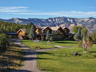

10/08/2024
$4,500,000
406.8 ac.
ACTIVE
Mesa County - 56106 Me Rd, Collbran, CO
Deacon Gulch Ranch is a truly unique 406.8 deeded acre property located near Collbran, Colorado. This exceptional mountain ranch offers an ideal blend of privacy, breathtaking views, and thoughtful improvements. Anchored by an 8,212 sq ft log home, the property also features a barn with an apartment, a metal workshop, greenhouse, and chicken house. With live water access, highly coveted water rights, and an abundance of wildlife, Deacon Gulch Ranch checks all the boxes for anyone seeking a premier mountain retreat.
At the heart of the property is a fully furnished and turnkey beautifully designed 8,212 sq ft log home featuring 6 bedrooms, 4.5 bathrooms, and over 4,000 sq ft of outdoor living spaces. The home offers a generous great room with a grand stone fireplace, a dedicated TV room, recreation room, workout space, a heated 689 sq ft garage, and a full outdoor kitchen and hot tub.
The ranch is equipped with a 3,420 sq ft barn that includes a 1,249 sq ft apartment, five horse stalls, and auxiliary rooms. For those in need of workspace or storage, the 56'x76' metal shop with concrete floors and large entrances is perfect for projects and equipment storage. The property also includes a 391 sq ft greenhouse and a 192 sq ft chicken house, making it ideal for self-sufficiency and sustainable living.
Deacon Gulch Ranch features 1.1 miles of Deacon Creek and two trout-filled lakes spanning 2.8 acres. With approximately 100 irrigated acres and significant water rights from the Mason Gulch Ditch (225 acre-feet) and the Seep Water Ditch (88 acre-feet), the property is primed for both agricultural and recreational pursuits, particularly fishing.
Located in Big Game Unit 421, known for its exceptional mule deer genetics and thriving elk herds, Deacon Gulch Ranch is an ideal location for hunting enthusiasts. The property provides a safe haven for wildlife as they migrate through the agricultural valleys and higher elevations of the Grand Mesa.
Deacon Gulch Ranch presents a once-in-a-lifetime opportunity to own a true mountain escape. With luxury amenities and abundant recreational and agricultural possibilities, this ranch is a unique find in the heart of Colorado.
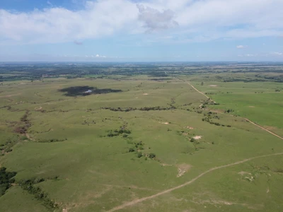

07/15/2025
Auction
309 ac.
ACTIVE
Washington County - 8245 Kansas 16, Hollenberg, KS
309 +/- Acres Washington Co. KS Land Auction
Thursday, November 6th, 2025 @ 6:00 PM
FNB Community Room (101 C ST) Washington, KS
Janet Jones Trust & Mike & Gina Rencin Trust - Seller
Legal Description:
S34, T01, R03, 6TH PRINCIPAL MERIDIAN, ACRES 150.2, NE4 LESS TR LYING N OF 25TH ROAD, S34, T01, R03, 6TH PRINCIPAL MERIDIAN, ACRES 79.3, E2, NW4 EXC RD ROW AND S34, T01, R03, 6TH PRINCIPAL MERIDIAN, ACRES 79.6, W2 NW4 EXC RD ROW
Broker’s Notes:
309 +/- Acres of PRIME Native Grass Pasture – Northern Washington County, Kansas
This 309 +/- acre tract of native grass pasture is a premium grazing opportunity located in the northern part of Washington County, Kansas. Nestled just 7 miles north of the town of Washington and only 5 miles south of the Nebraska state line, this property lies in a prime ranching area with convenient access to livestock markets in both states. Surrounded by several square miles of contiguous pastureland and just 1.5 miles east of the Washington County State Lake, this property offers privacy, productivity, and a turnkey setup for cattle producers.
The entire pasture consists of clean, well-managed native grass with a high forage value. The current owner has been proactive in pasture management, spraying the entire tract in late June to control any invasive brush or weed pressure—despite the fact that the grassland was already in excellent condition. This commitment to stewardship ensures that the pasture remains clean, productive, and able to support a high stocking rate. The rolling terrain and expansive views of the surrounding region make this a visually appealing and highly functional cattle property.
Water is one of the most critical components of any pasture, and this tract is exceptionally well-watered. The property is supplied by natural springs and spring-fed tanks, providing year-round water reliability. To further enhance livestock distribution and reduce overgrazing around a single source, two new stock tanks were recently installed. These additions make this pasture ready to support a full season grazing operations with confidence.
Infrastructure is equally strong. The perimeter fencing is in very good condition, consisting primarily of 4 and 5-wire barbed wire. The fencing has been well maintained and is cattle tight. Additionally, an all-pipe corral system is in place, providing a safe and efficient setup for working and loading livestock. These improvements offer immediate utility and reduce the need for costly upgrades.
Access to the property is outstanding. The pasture fronts a full mile of road along 25th Road, just one mile west of Quivira Road—a paved, county-maintained blacktop. The proximity to the blacktop and nearby markets adds significant value in terms of operational efficiency and logistical flexibility.
This is a rare opportunity to acquire a well-located, clean native grass pasture with excellent water, fencing, and handling facilities. The size and condition of the tract make it ideal for expanding a cow-calf operation, backgrounding cattle, or simply owning a highly productive piece of Kansas grassland in a strong ranching area.
Property Highlights:
- 309 +/- acres of high-quality native grass
- Located 7 miles north of Washington, KS, and 5 miles south of the Nebraska border
- 1.5 miles east of Washington County State Lake
- Surrounded by thousands of acres of pastureland
- Multiple spring-fed water sources including natural springs and spring tanks
- Two new spring tanks recently installed for improved water access
- Recently sprayed (June 2025) to maintain clean, weed-free grass
- Strong 4 and 5-wire barbed wire perimeter fencing
- All-pipe corral system in excellent working condition
- 1 mile of road frontage on 25th Road
- 1 mile west of Quivira Road (paved county blacktop)
- Excellent access to cattle markets in both Kansas and Nebraska
An access easement is in place for the property to the south, utilizing the existing gate on the west portion of pasture on 25th Road by the coral, where an established pasture road proceeds south from this gate to the south gate where the pasture road connects to the property on the south.
This property is ready to go for the next livestock operator. Whether you're expanding your existing operation or investing in quality pastureland, this tract checks all the boxes for water, grass, infrastructure, and location.
Directions to Property:
From Washington, KS…travel north out of Washington on Quivira Road for 7 miles to 25th Road. Travel west on 25th Road for 1 mile where you’ll arrive at the northeast corner of the property which is located on your left (south side of 25th Road). From that point the property will be on your left (south side of 25th Road) for 1 mile. Watch for Signs!
From Steele City, NE…travel south out of town on Ida Road for 2.5 miles to the Kansas/Nebraska State Line. Continue on south on Quivira Road (Road name changed at state line) for 5 miles till you reach 25th Road. Continue right (west) on 25th Road Travel west on 25th Road for 2 miles until you arrive at the northeast corner of the property which is located on your left (south side of 25th Road). From that point the property will be on your left (south side of 25th Road) for 1 mile. Watch for Signs!
2024 Property Taxes: $1325.39
Terms & Possession: 10% down day of sale, balance due at closing on or before 12/10/25. Possession at closing. Seller to pay 2025 and prior years taxes. Title insurance, contract preparation, escrow and closing costs to be split equally between buyer and seller. Property to be sold “AS-IS, WHERE-IS” subject to items on a survey, claims of adverse possession, and all easements and exceptions of record. All inspections should be made prior to the day of the sale. This is a cash sale and is not subject to financing or any other contingencies, have your financing arrangements made prior to auction. Midwest Land and Home is acting as a Seller’s Agent and represents the seller’s interest. All information has come from reliable sources; however, potential buyers are encouraged to verify all information independently. Seller expressly disclaims any liability for errors, omissions or changes regarding any information provided for these sales. Potential purchasers are strongly urged to rely solely upon their own inspections and opinions in preparing to purchase property and are advised not to rely on any representations made by the seller or their agents. Statements made the day of sale take precedence over all other printed materials. Aerials are representations and not guaranteed to be actual property lines. Anthony Bruna, Bruna Law, LLC, Attorney for Sellers, Pony Express Title, escrow, title & closing agent.

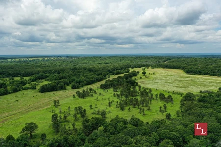
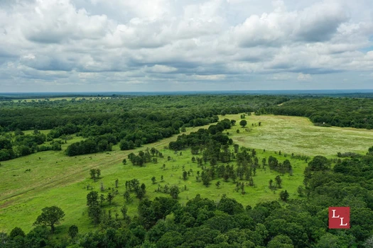
03/01/2024
$6,017,115
1851.42 ac.
ACTIVE
Coal County - 37636 County Road 1690, Coalgate, OK
Motivated Seller!
Location:
*Coalgate - 7 miles
*Ada - 30 miles
*Oklahoma City - 113 miles
*DFW - 143 miles
Access:
*County road
Water:
* Caney Creek
* Little Caney Boggy Creek
* 10 ponds
Utilities:
*Electric
Climate:
*Approximately +/- 45 inches of annual precipitation
Minerals:
*Surface Only
Wildlife:
*Whitetail Deer
*Wild Turkey
*Waterfowl
*Dove
*Wild Hogs
Fishing:
*Largemouth Bass
*Smallmouth Bass (stocked in a spring-fed pond)
*Bluegill
Terrain:
*Rolling wooded hillsides with stunning boulder outcroppings
*Elevation ranges from 640' to 790'
General Description:
Located in central Coal County in the southeast part of Oklahoma, Hat Creek Ranch is a 1,851 +/- acre contiguous tract of land that exemplifies the qualities of this region. The property is multifunctional and features numerous functional improvements perfect as a combination ranch for both cattle and recreation.
The land itself has a great amount of diversity such as rocky, woodland hills that lead to open meadows suited for grazing or hay production. Deep rugged drainages also traverse the landscape and create perfect travel corridors for mature whitetail deer. There are several water features on the property suited for agricultural or recreational purposes. Flowing through the eastern section of the ranch is Caney Creek which is the largest of the water features. Caney Creek is a slow-flowing body of water lined with stunning mature timber. On the western side of the ranch lie the headwaters of the Little Caney Boggy Creek. A preliminary review of the topo map indicates potential for a 35-40 +/- acre lake site in the upper end of Little Caney Boggy Creek. There are also 23 ponds scattered across the property within the draws and meadows. The most notable is a 3.5+/- acre clear water pond approximately 30 ft deep that is stocked with Smallmouth bass.
Recreation plays a major part in the identity of Hat Creek Ranch. For the last 20 years, careful steps have been taken to maximize the whitetail deer population in the area to produce impressive, mature bucks. The Seller believes they have achieved at least a 2:1 buck-to-doe ratio. Countless Cy Curtis and Pope & Young trophies have been harvested through the years with the largest buck scoring over 190". Food plots, feeders, and hunting stands & blinds are strategically placed across the ranch to enhance the hunting experience. The avid hunter could also pursue ducks, wild pigs, turkeys, and other small game that live in the forests and meadows of Hat Creek Ranch. Another opportunity that lends itself to the outdoorsman would be fishing. The ponds of the property offer the chance to catch various species of sunfish, catfish, largemouth, and smallmouth bass. Smallmouth bass were stocked in the 3.5+/- spring-fed pond and they are a voracious predator that is known for its prowess in the fishing community.
Whether it is hunting, fishing, or just the tranquility of being in nature, this property has something for everyone. Call us today to learn more about this fabulous property or to schedule your exclusive showing!
If you are not already on the Legendary Land Company website, please follow the "Property Website" link.
When purchasing a property listed by Legendary Land Company, a Buyer's Broker, if applicable, must be identified on first contact and must be present at the initial showing of the property in order to participate in a real estate commission. If these conditions are not met, compensation, if any, will be at the sole discretion of Legendary Land Company.

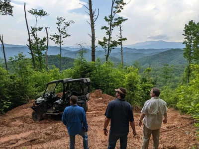

03/07/2019
$199,900
44 ac.
ACTIVE
Caldwell County - Blowing Rock, NC
Call 855-568-5263
This property has it all. Minutes to downtown Blowing Rock. Views in every direction. South Facing. It has a trout stream that flows through the center of the property. It has underground power. No HOA. No restrictions. Flat buildable areas. The Ridgeline build site is a flat 2-3 acres with views of Grandfather Mountain, Table Rock Mountain, and multiple mountain ranges. The best part is that the tract adjoins the Pisgah National Forest The Pisgah game land section. The Pisgah abuts this property on three sides. Over a mile borders the National Forest Around 6000 feet.
Up to 44 Acre National Forest Trophy Tract/Lot with Long Range Views Near Blowing Rock.
- Rare Blue Ridge Mountain Property Asset
NO HOA. Live the way you want with no restrictions
Trophy Property and good quality Land, is getting more challenging to acquire. This property was family owned for over 100 years - a rare find. This tract has it all. Perfect for Vacations, Retirement, short term rentals with high potential return on investment. You can subdivide into 10-acre parcels.
1. Long Range views. You can see over six counties from a 23-acre flat ridge top knoll/build site.
2. Tract joins the Pisgah National Forest. Your backyard is 850 square miles on the Pisgah National Forest.
3. Views of Grandfather Mountain, Table Rock Mountain, and many more mountain ranges.
4. Popular Roaring Creek, a Spring fed Creek, runs through this property.
5. Minutes from downtown Blowing Rock
6. Close to Boone, Banner Elk, and Foscoe.
7. Cut out driveway and build site.
8. Perfect for camping or Cabins.
9. Underground Power
10. Septic and Well ready (or use a Spring)
11. No HOA. Live the way you want.
Guaranteed Financing available.
Follow us on Instagram for the latest inventory. LWLand_Development
855-568-5263


08/12/2024
$15,995,000
758 ac.
ACTIVE
Medina County - Hondo, TX
Two Creeks Ranch, 758 acres located just 30 minutes west of San Antonio in Medina County, is a memory-making, live-water destination designed to make family, friends or business associates feel right at home in natural Texas.
When guests enter the simple, but elegant front gate on County Road 451 they are struck by the oak-lined, chip-sealed Knippa stone driveway and the flanking irrigated pecan orchard with more than 500 productive trees. Landscaping throughout was designed and installed by the late Marc Tellepson and the late Mark Scioneaux, both of Houstons famed Tellepsons Landscaping Company. The ranch has additional frontage on County Road 455.
By the time guests arrive at the main compound featuring the two dogtrot lodges that reflect Texas pioneer heritage and the adjoining renovated barn and primary gathering space known as the Party Barn, they know theyre somewhere special.
The Land
Nestled in an ecological transition zone, Two Creeks, as the name implies, offers the beautiful live water and legacy oaks of the Hill Country and the varied brush that marks superlative wildlife habitat in South Texas. In addition to majestic live oaks, the ranch is shaded by native pecan trees in the bottomlands of Hondo and Verde Creeks and old-growth bull mesquite throughout.
The Water
The creeks border the ranch on two sides. Verde Creek, which is a year-round creek, courses through the ranch for 1.7 miles on the east, providing private access to both banks. Hondo Creek runs along the south border for about 1.85 miles.
A 7 acre lake that measures about 22 feet at its deepest point is stocked with bass, perch and forage fish. It is peanut-shaped with a jutting peninsula, which maximizes bank frontage and allows for plenty of angling fun. In case guests prefer to swim, carefully stacked native rocks create the perfect place to launch into the lake.
Groundwater is also plentiful. Two Creeks Ranch has two center pivots supplied by an Edwards Aquifer irrigation well with 60 acre-feet of transferable Edwards water. There is an additional well on the property.
The Wildlife
Two Creeks Ranch has been managed primarily for doves, but whitetail deer, feral hogs, free-ranging exotics abound. A variety of varmints, small game and non-game species also call the low-fenced ranch home.
The Lifestyle
Guests can sharpen their shooting skills and pass an enjoyable afternoon at the five-stand skeet range outfitted with six movable trap houses. Once the smoke has cleared, they can congregate at the nearby Gun Room, a 945 square foot gathering space that includes a wet bar, drink coolers, a 72-inch TV as part of the indoor sitting area, gun lockers, WiFi and a built-in sound system.
For those who prefer to be outdoors, a 1,850 square-foot covered porch area, located between the Gun Room and the skeet range, is the perfect spot. Guests can sit in the shade of two ancient live oaks as they enjoy conversation and a cool breeze.
Accommodations
A set of two identical 3,130 square-foot dogtrot lodges, crafted from reclaimed and washed barnwood epitomize the clean country style that defines Two Creeks Ranch and serve as the main compounds focal point. Unlike their historical Texas predecessors, the dogtrots are enclosed.
Each lodge, outfitted with WiFi, a built-in sound system and wood burning fireplace, sleeps up to 12 people. The spacious porches, on front and back, make it easy to take the conversation outdoors.
The downstairs encompasses 2,072 square feet and includes four bedrooms with two double beds, a coffee bar, TV and a private bath with heated floor. The upstairs features two king suites with a coffee bar, TV and a private bath with heated floor.
A short walk down a crushed granite path bordered with concrete brings guests to the 11,600-square-foot Party Barn. Crafted from an existing barn, the Party Barn combines entertainment and dining space with storage and workspace under one roof.
The dining hall and the state-of-the-art, custom chefs commercial kitchen encompass about 2,000 square feet and can accommodate up to 50 guests for special events. The mesquite-topped bar is set off by the shiplap walls adorned with metal touches reminiscent of modern ranchhouse style.
The interior of the Party Barn also includes two big screen TVs, shuffleboard, video golf and Buck Hunter as well as self-serve drink coolers, WiFi, a built-in sound system and two restrooms.
An outdoor pass-through transitions into a 3,600 square-foot work barn, which includes a gym and loft storage area. In addition, there are three small apartments: the 180 square-foot bunk room has four bunkbeds and a private bath; the 216 square-foot apartment, known as Joes Room, has a queen bed and a private bath; and the 430 square-foot downstairs room has two queen beds and a private bath.
Because a party is even better outdoors, the Party Barn has a 3,000 square-foot covered porch shaded by Mexican sycamores. The porch has a built-in sound system, a TV, large outdoor fans, a fire pit and an outdoor bar with an ice machine.
A second compound, featuring the Casa Verde House, the Ranchero House and a large storage barn, is easily accessible over improved ranch roads.
The newly renovated, two-story Casa Verde House encompasses 2,000 square feet with the bonus of a wraparound porch. The downstairs is dedicated to fun with a wet bar and shuffleboard. It also includes a restroom.
The upstairs features a full kitchen and laundry room as well as a king suite with a private bath and bedroom with a queen bed and two doubles. A full bath completes the upstairs.
The nearby three-bedroom/two-bath Ranchero House, a traditional ranch-style home, features a front porch as well as a screened porch. A kitchen office, laundry room, covered carport and detached game room round out the space.
Water is delivered to all these houses by the Yancey Water Supply Corporation.
Infrastructure
The 5,900 square-foot Maintenance Barn, located in proximity to the main compound, is the site of the covered game cleaning station as well as the walk-in refrigerator and freezer. It also includes restrooms and additional storage.
The 800 square-foot Laundry Building is conveniently situated within easy reach of the dogtrot lodges and Party Barn. Despite its utilitarian purpose, the stone building is one of the ranchs most beautiful.
The main compound also has 3,000 square feet of covered parking. The ranch roads are caliche or improved, built-up dirt roads.
All furnishings with the dogtrots as well as the entertainment area and commercial kitchen transfer with the sale.
In addition, the 22,500 square-foot Hangar Barn, made from a converted airplane hangar, provides both individual storage rooms as well as loft storage rooms.
The Opportunity
Two Creeks Ranch is the best of old and new Texas. Built to surround family, friends and business associates in the time-tested warmth of hospitality and the well-watered landscape of natural Texas. Claim Two Creeks Ranch as your place. A one-of-a-kind destination for making memories that will color your world.
To experience the natural style of Two Creeks Ranch, a premier Texas destination, for yourself, call Howard W. Hood with Hood Real Estate Inc. at (830) 739-3815. Listed for $15,995,000.


1
2
3
4
5
6
7

