
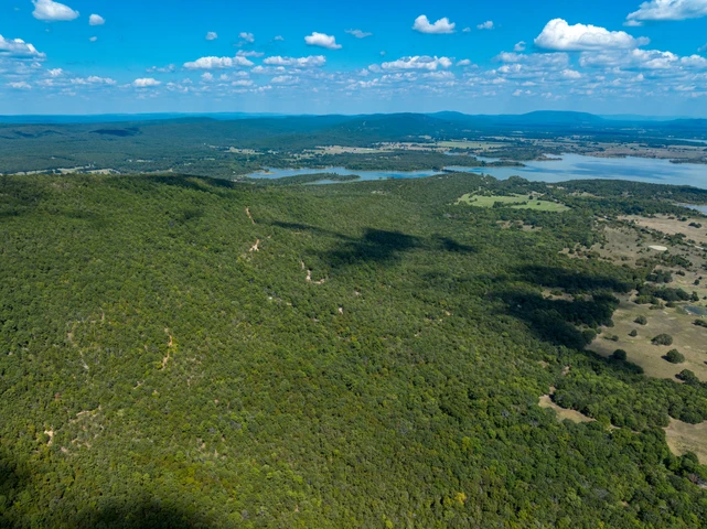
MOUNTAIN-TOP VIEWS OF SARDIS LAKE IN SOUTHEAST OKLAHOMA
TBD Wolf Mountain Rd., Sardis, OK | Lat/Lng: 34.6944, -95.4086
$140,532
8.4 ac.
07/17/2025
ACTIVE

Description
Situated at the top of the gated community of The Views by Sardis Lake, this gorgeous property offers seclusion and fantastic views with limited restrictions to protect your investment.
The terrain is beautifully varied with ideal building sites on the parcel, making it the perfect spot for a weekend getaway cabin or full-time residence. The land is covered with a mature timber native to southeastern Oklahoma. Elevated above the north shore of Sardis Lake, youll have spectacular mountain-top lake views. Sardis Lake spans 14,360 acres and offers many recreational activities including skiing, boating and some of the best fishing in Oklahoma. Additionally, there are several hundred acres of underutilized public land surrounding the lake which offer great hunting opportunities for trophy-size whitetail deer, eastern turkey, feral hogs, black bear, and numerous small game species. The 19,237-acre Pushmataha Wildlife Management area is just a quick drive where many outdoor adventures await. With the security of a gated community and well-spread out neighbors, you have the balance of privacy and comfort. Contact us for Limited Conditions & Restrictions
The breathtaking tract overlooks Sardis Lake and is accessed by a nice gravel road from paved Sardis Cemetery Rd. A 4-wheel drive SUV or pickup is advised but the view is worth the challenge!
Visiting the Property: There is a gate with a lock, so please contact us for entry information to see this property.
Access to the property is via Wolf Mountain Road coming in from SW 1050th Ave. right off Sardis Cemetery Road. See the Google Maps link and map photos for details on directions.
I have included a complete set of ACTUAL property photos all boundary outlines in footage are approximate. I have included everything I know about the property below.
WHATS CLOSE?
7.5 miles to Yanush Store
9 miles to Bolen Hollow State Public Hunting Area
12.9 miles to Dollar General Market & Post Office in Clayton
16 miles to Pushmataha Wildlife Management Area
25 minutes to Clayton Lake State Park
1 hour to McAlester
2.5 hours to Tulsa
2 hours & 45 minutes to OKC
3 hours to Dallas
PROPERTY DETAILS
Size (Acres): 8.4 +/-
General Location: TBD Wolf Mountain Road, Clayton, OK 74536
APN or Other ID: 7757-00-000-020-0-000-00
Subdivision: The Views by Sardis Lake, Contact Us for Limited Conditions & Restrictions
Legal Description: Lot 20 of the Views by Sardis Lake, a subdivision in Latimer County, Oklahoma
Approx. GPS:
34.693528, -95.409833
34.695398, -95.409854
34.695407, -95.407740
34.693932, -95.407729
34.693924, -95.408523
34.694041, -95.408766
34.693873, -95.409514
34.693551, -95.409621
Property Type: Rural Land
Land Use: Single Family Residence
Zoning: Residential (NEC). For more information, contact Latimer County 918.465.3031 or visit their website
HOA/POA Fees: No, Click Here for Limited Conditions & Restrictions
Terrain: Varied
General Elevation: Approx. 1,200 ft
Power: Would be by generator, solar or wind
Phone: Mobile/Satellite/Alternative
Water: Would need to drill well or use alternative system
Sewer: Would need septic or alternative system
Roads: Dirt, 4WD Recommended
Title Info: Clear Title, Conveyed from LG Solutions LLC
Annual Property Taxes: Approx. $50
Doc Fee: Terms & Cash Responsibility of Buyer (To be closed through Latimer County Abstract & Title)
Details
County: Latimer
Zipcode: 74536
Property Type One: Recreational Property
Property Type Two: Residential Property
Property Type Three: Hunting Land
Brokerage: Circle7Land.com
Brokerage Link: circle7land.com
Apn: 775700000020000000

Dave Ayres
Circle7Land.com
(720) 807-7778
By clicking the button, you agree to our Terms of Use and Privacy Policy.


Nearby Listings
Le Flore County, OK

$115,500 - 23 ac.
Le Flore County, OK

$22,900 - 3 ac.
Le Flore County, OK

$39,900 - 3 ac.
Pittsburg County, OK

$4,395,000 - 1340 ac.
Pittsburg County, OK

$899,000 - 33 ac.
Pittsburg County, OK

$1,299,000 - 72 ac.
Pushmataha County, OK

$135,000 - 20 ac.
Le Flore County, OK

$595,000 - 140 ac.
Pittsburg County, OK

$480,000 - 60 ac.
Pittsburg County, OK

$135,000 - 41 ac.